IMAGES TAKEN NEAR TO
County Bridge, RADSTOCK, BA3 3AA
Introduction
This page details the photographs taken nearby to County Bridge, BA3 3AA by members of the Geograph project.
The Geograph project started in 2005 with the aim of publishing, organising and preserving representative images for every square kilometre of Great Britain, Ireland and the Isle of Man.

There are currently over 7.5m images from over14,400 individuals and you can help contribute to the project by visiting https://www.geograph.org.uk
Image Map
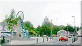
Images are licensed for reuse under creativecommons.org/licenses/by-sa/2.0
Notes
- Clicking on the map will re-center to the selected point.
- The higher the marker number, the further away the image location is from the centre of the postcode.
Image Listing (84 Images Found)
Images are licensed for reuse under creativecommons.org/licenses/by-sa/2.0
Image
Details
Distance
1
Site of former stations in Radstock, 2006
View westward: on the right was 'Radstock North' station on the ex-S&D Joint line from Bath towards Midsomer Norton, Evercreech Junction, Templecombe and Bournemouth, on the left was the ex-GWR 'Radstock West' towards Bristol on the line to Frome. (See also Image]). The old colliery winding-wheel is displayed outside the Radstock (Mining) Museum.
Image: © Ben Brooksbank
Taken: 2 Jul 2006
0.01 miles
2
Site former Radstock Stations, 2006
View southward from the A367 Wells Road, in the centre of town where the two stations used to be, side by side. Nearest was the ex-GWR (Bristol, Radstock & Frome line) - Frome to the left (closed 2/11/59, goods 15/6/64). Just beyond was the Somerset & Dorset station ('Radstock North' from 9/49) on the S&D Bath (to left) - Evercreech Junction - Templecombe - Bournemouth West main line (closed 7/3/66)
Image: © Ben Brooksbank
Taken: 2 Jul 2006
0.01 miles
3
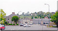
Main Road through Radstock close to Museum
Museum out of shot to the right
Image: © John Firth
Taken: 4 Sep 2017
0.02 miles
4
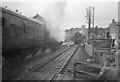
Somerset & Dorset line trains crossing at Radstock North
On the left LMS 4F 0-6-0 departs with the 3.20pm from Bath Green Park to Templecombe. Arriving is 76014 (built Horwich 5/53, withdrawn 9/66) with the 1.10pm from Bournemouth to Bath. They are both about to pass over one of the two notorious level crossings in Radstock that caused much frustration to motorists on the A367 Fosseway. The other crossing (over the GWR line) is immediately to the left of the one seen here. The two lines ran alongside each other for almost a mile westward from here. Date of photo uncertain but it was a wet day in June or July 1964!
This photo was taken from the end of the platform shown here: Image
Image: © Martin Tester
Taken: Unknown
0.02 miles
6
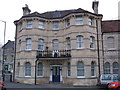
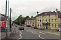
Former Bell Hotel, Radstock
The former Bell Hotel, Radstock. Now used as residential flats.
Image: © Nigel Shoosmith
Taken: 21 Dec 2008
0.02 miles
7
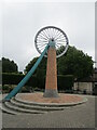
Miners' Memorial, Radstock
The pit head wheel came from a colliery at nearby Kilmersdown.
Image: © Jonathan Thacker
Taken: 23 Sep 2021
0.02 miles
8

Pit wheel and museum, Radstock
The wheel is from the nearby Kilmersdon Colliery.
Image: © David Martin
Taken: 25 Jul 2014
0.02 miles
9
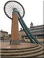
Pit Wheel, Radstock
This is the relocated pit winding gear wheel from Kilmersdon Colliery which closed in 1973. The former market hall in the background is now the Radstock Museum.
Image: © Derek Harper
Taken: 25 Feb 2009
0.02 miles
10
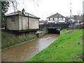
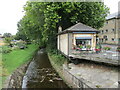
Wellow Brook, Radstock
Looking upstream [locally west]. Named as the River Somer on the 1902 OS map.
Image: © Christine Johnstone
Taken: 2 Apr 2018
0.02 miles