IMAGES TAKEN NEAR TO
White City Welton, RADSTOCK, BA3 2XD
Introduction
This page details the photographs taken nearby to White City Welton, BA3 2XD by members of the Geograph project.
The Geograph project started in 2005 with the aim of publishing, organising and preserving representative images for every square kilometre of Great Britain, Ireland and the Isle of Man.

There are currently over 7.5m images from over14,400 individuals and you can help contribute to the project by visiting https://www.geograph.org.uk
Image Map
Images are licensed for reuse under creativecommons.org/licenses/by-sa/2.0
Notes
- Clicking on the map will re-center to the selected point.
- The higher the marker number, the further away the image location is from the centre of the postcode.
Image Listing (2 Images Found)
Images are licensed for reuse under creativecommons.org/licenses/by-sa/2.0
Image
Details
Distance
1
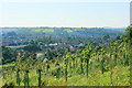
2008 : South west from Millard's Hill
Welton is at the bottom of the hill to the left. We are looking at Midsomer Norton straight ahead.
Make the most of it, you won't see anything but trees from here soon.
Image: © Maurice Pullin
Taken: 20 Sep 2008
0.18 miles
2

Former chapel, Welton
There are two former chapels on this site; to the left is a modern extension at the rear of a neo-gothic baptist chapel facing West Road, which is listed https://historicengland.org.uk/listing/the-list/list-entry/1115225 , with the date given unequivocally as 1839.
This neo-classical facade, which also has a quatrefoil, faces Millard's Hill and has a tablet inscribed "Primitive Methodist Chapel AD 1858", is not listed. (Both have been converted into flats, known as Millard's Court.) https://docplayer.net/85018444-Midsomer-norton-and-welton-conservation-area-character-appraisal.html describes this as "built
of squared coursed white lias limestone rubble with oolitic limestone
dressings and semi-circular headed windows and central door". But it gives a date of 1935 for the listed building next door. I think, however, that must be the date of the extension.
Image: © Derek Harper
Taken: 7 Oct 2009
0.25 miles