IMAGES TAKEN NEAR TO
Gullock Tyning, RADSTOCK, BA3 2UH
Introduction
This page details the photographs taken nearby to Gullock Tyning, BA3 2UH by members of the Geograph project.
The Geograph project started in 2005 with the aim of publishing, organising and preserving representative images for every square kilometre of Great Britain, Ireland and the Isle of Man.

There are currently over 7.5m images from over14,400 individuals and you can help contribute to the project by visiting https://www.geograph.org.uk
Image Map (Loading...)


Getting Data...Please wait
Leaflet Map data © OpenStreetMap
Images are licensed for reuse under creativecommons.org/licenses/by-sa/2.0
Notes
- Clicking on the map will re-center to the selected point.
- The higher the marker number, the further away the image location is from the centre of the postcode.
Image Listing (28 Images Found)
Images are licensed for reuse under creativecommons.org/licenses/by-sa/2.0
Image
Details
Distance
1
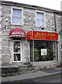
Jackie Chan's
A small takeaway in Midsomer Norton; perhaps Mr Chan may have some other business interests in case the film work dries up? Surely not.
Image: © Neil Owen
Taken: 19 Dec 2013
0.09 miles
2
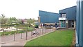
Midsomer Norton Sports Centre
My kids enjoyed their swim in the pool which is in a convenient town centre location.
Image: © Paul Collins
Taken: 1 May 2017
0.11 miles

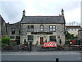
4
The Stones Cross
Reputedly the best place for a good night's rock. The pub, which has been on this site for well over a century, is named after the crossroads it faces - Stone's Cross.
Image: © Neil Owen
Taken: 14 Feb 2013
0.14 miles
5

Propped up
Scaffolding surrounds some houses along the High Street.
Image: © Neil Owen
Taken: 14 Feb 2013
0.14 miles
6
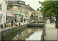
2009 : River Somer, Midsomer Norton
The river flows along the centre of High Street. Would have been in a dreadful state in the good old days.
Image] shows the scene a little further along.
Image: © Maurice Pullin
Taken: 10 Aug 2009
0.15 miles
7
"Mallards", Midsomer Norton High Street
Image: © Nigel Shoosmith
Taken: 12 May 2007
0.17 miles
8

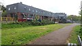
Path Through Former Railway
In the 19th century a path passed under the railway at this point, joining the town with Norton Hill Farm. Later the alignment became Pit Road and was the main access to Norton Hill Colliery (No. 1). Today the railway and colliery have gone but a spoil heap remains, merging with the railway embankment, just visible on the left.
Image: © Paul Collins
Taken: 1 May 2017
0.19 miles
9
Industrial Buildings on site of Colliery
These buildings stand on or almost on the site of Norton Hill Colliery (No. 1). The tarmac path is the site of sidings serving the colliery.
Image: © Paul Collins
Taken: 1 May 2017
0.19 miles