IMAGES TAKEN NEAR TO
West Road, RADSTOCK, BA3 2TP
Introduction
This page details the photographs taken nearby to West Road, BA3 2TP by members of the Geograph project.
The Geograph project started in 2005 with the aim of publishing, organising and preserving representative images for every square kilometre of Great Britain, Ireland and the Isle of Man.

There are currently over 7.5m images from over14,400 individuals and you can help contribute to the project by visiting https://www.geograph.org.uk
Image Map (Loading...)


Getting Data...Please wait
Leaflet Map data © OpenStreetMap
Images are licensed for reuse under creativecommons.org/licenses/by-sa/2.0
Notes
- Clicking on the map will re-center to the selected point.
- The higher the marker number, the further away the image location is from the centre of the postcode.
Image Listing (21 Images Found)
Images are licensed for reuse under creativecommons.org/licenses/by-sa/2.0
Image
Details
Distance
1
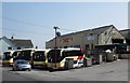
Centurion Travel, West Road, Midsomer Norton
Image: © Roger Cornfoot
Taken: 23 Apr 2010
0.03 miles
2
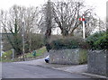
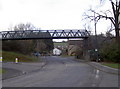
Off line!
The footbridge just visible to the left of shot replaced the old railway bridge some time ago, but certain railway apparatus seems to have been retained near to its original location.
Image: © Neil Owen
Taken: 14 Feb 2013
0.05 miles
3
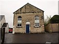
Former chapel, Welton
There are two former chapels on this site; to the left is a modern extension at the rear of a neo-gothic baptist chapel facing West Road, which is listed https://historicengland.org.uk/listing/the-list/list-entry/1115225 , with the date given unequivocally as 1839.
This neo-classical facade, which also has a quatrefoil, faces Millard's Hill and has a tablet inscribed "Primitive Methodist Chapel AD 1858", is not listed. (Both have been converted into flats, known as Millard's Court.) https://docplayer.net/85018444-Midsomer-norton-and-welton-conservation-area-character-appraisal.html describes this as "built
of squared coursed white lias limestone rubble with oolitic limestone
dressings and semi-circular headed windows and central door". But it gives a date of 1935 for the listed building next door. I think, however, that must be the date of the extension.
Image: © Derek Harper
Taken: 7 Oct 2009
0.06 miles
4
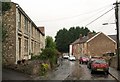
Millard's Hill, Welton
The foot of the hill in steady rain. By the time it has reached the junction with Station Road and West Road (the A382) behind the white end terrace it has crossed into Image
Image: © Derek Harper
Taken: 7 Oct 2009
0.06 miles
5
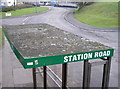
No more steam and soot
The footbridge over Station Road is a modern affair that carries the National Cycle Route 24 and pedestrians. But not so long ago it was a much more substantial structure that saw steam and diesel trains since the founding of the Bristol and North Somerset Railway in 1873. The line was absorbed into the Great Western Railway later on and continued to serve many of the local coal fields until 1964.
Much of the western embankment has been lost and with it a projecting bracket. See Image] for a view from the bridge.
Image: © Neil Owen
Taken: 14 Feb 2013
0.06 miles
6
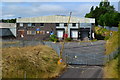
Disused factory site
Former Welton Bibby & Baron paper bag site in Station Road.
Image: © David Martin
Taken: 2 Aug 2018
0.07 miles
7
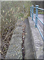
Retained features
The old wall of the former GWR line bridge at Station Road has been kept but the new working to turn it into a cyclepath is a simple concrete mass.
Image: © Neil Owen
Taken: 14 Feb 2013
0.07 miles
8
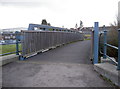
Station Road footbridge
Looking westwards over what was the old railway line. See Image] for a location view.
Image: © Neil Owen
Taken: 14 Feb 2013
0.07 miles
9
Crusty on top
A bus stop shelter, close to some trees and showing the many lichens able to survive in difficult places.
Image: © Neil Owen
Taken: 14 Feb 2013
0.07 miles
10
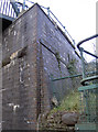
A brick buttress
The old railway line has been gone for many years now, but the major part of the eastern side of the bridge in Station Road remains to remind travellers of its past. Modern (and lighter) railings are of no burden.
Image: © Neil Owen
Taken: 14 Feb 2013
0.07 miles