IMAGES TAKEN NEAR TO
Steam Mills, RADSTOCK, BA3 2JY
Introduction
This page details the photographs taken nearby to Steam Mills, BA3 2JY by members of the Geograph project.
The Geograph project started in 2005 with the aim of publishing, organising and preserving representative images for every square kilometre of Great Britain, Ireland and the Isle of Man.

There are currently over 7.5m images from over14,400 individuals and you can help contribute to the project by visiting https://www.geograph.org.uk
Image Map
Images are licensed for reuse under creativecommons.org/licenses/by-sa/2.0
Notes
- Clicking on the map will re-center to the selected point.
- The higher the marker number, the further away the image location is from the centre of the postcode.
Image Listing (11 Images Found)
Images are licensed for reuse under creativecommons.org/licenses/by-sa/2.0
Image
Details
Distance
1
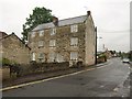
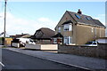
Former mill, Midsomer Norton
"C18 or early C19. Large 3 storey mill block in coursed limestone rubble" http://www.imagesofengland.org.uk/details/default.aspx?id=31979 . The mill, whose address has been renumbered since the listing, is on a continuation of Withies Park called "Steam Mills". At the left end, the building extends almost to the River Somer.
Image: © Derek Harper
Taken: 7 Oct 2009
0.03 miles
2
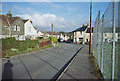
2009 : Millfield, continuing to Laburnum Grove
Part of a housing development to the south of Midsomer Norton.
Image: © Maurice Pullin
Taken: 16 Jan 2009
0.07 miles
3
Cautletts Close, Midsomer Norton
Cautletts Close is a cul-de-sac off Withies Park. The housing on it is across the River Somer, and the metal parapets of the bridge are visible a few metres ahead. Riverside Walk is a footpath running along the rear of the housing off Withies Park and beside the small river.
Image: © Derek Harper
Taken: 7 Oct 2009
0.18 miles
4
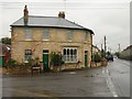
House on Redfield Road, Midsomer Norton
This stone building, with pronounced quoins, is at the corner with Chilcompton Road (right), which explains its less than regular shape. Both junction and house also appear in Image
Image: © Derek Harper
Taken: 7 Oct 2009
0.19 miles
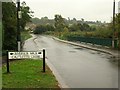
5
Houses in Chilcompton Rd
These houses are on the east side of Chilcompton Rd just north of its junction with Hillside Rd and just south of the junction with Laburnum Grove
Image: © Nigel Mykura
Taken: 2 Nov 2020
0.20 miles
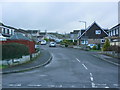
6
Junction, Midsomer Norton to Chilcompton and Clapton Road
Image: © Dominic Dawn Harry and Jacob Paterson
Taken: 18 Feb 2006
0.20 miles
7
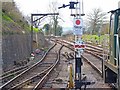
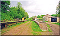
Midsomer Norton South Station
The Somerset & Dorset Heritage Trust was established in 1992, and has restored the Midsomer Norton South station. Future plans include relaying tracks to Chilcompton, the next station south, via the Chilcompton Tunnel. This view shows the tracks, heading towards Chilcompton, which extend for a quarter of a mile.
Image: © mike smith
Taken: 25 Mar 2012
0.24 miles
8
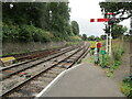
The end of the platform, Midsomer Norton
A restored section of the Somerset and Dorset Joint Railway https://en.wikipedia.org/wiki/Somerset_and_Dorset_Joint_Railway
Image: © Jonathan Thacker
Taken: 23 Sep 2021
0.24 miles
9
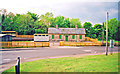
Midsomer Norton & Welton South station, under restoration 2001
View NE, towards Bath: ex-S&D Joint main line Bath - Evercreech Junction - Templecombe -Bournemouth West, closed 7/3/66. The station and some track-bed were acquired by the Somerset & Dorset Railway Heritage Trust in 1992 [?]; since 2001 they have relaid track towards Chilcompton and are running trains. See http://www.sdjr.co.uk/ . See also Image] and Image
Image: © Ben Brooksbank
Taken: 15 May 2001
0.24 miles
10
Midsomer Norton & Welton South station, during restoration 2001
View NW of the exterior on the Down side of the former S&D Joint station, closed 7/3/66, under restoration by the Somerset & Dorset Joint Railway Heritage Trust. (See also Image] and cf. Image]).
Image: © Ben Brooksbank
Taken: 15 May 2001
0.24 miles