IMAGES TAKEN NEAR TO
Redfield Grove, RADSTOCK, BA3 2JU
Introduction
This page details the photographs taken nearby to Redfield Grove, BA3 2JU by members of the Geograph project.
The Geograph project started in 2005 with the aim of publishing, organising and preserving representative images for every square kilometre of Great Britain, Ireland and the Isle of Man.

There are currently over 7.5m images from over14,400 individuals and you can help contribute to the project by visiting https://www.geograph.org.uk
Image Map (Loading...)


Getting Data...Please wait
Leaflet Map data © OpenStreetMap
Images are licensed for reuse under creativecommons.org/licenses/by-sa/2.0
Notes
- Clicking on the map will re-center to the selected point.
- The higher the marker number, the further away the image location is from the centre of the postcode.
Image Listing (26 Images Found)
Images are licensed for reuse under creativecommons.org/licenses/by-sa/2.0
Image
Details
Distance
2
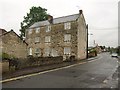
Former mill, Midsomer Norton
"C18 or early C19. Large 3 storey mill block in coursed limestone rubble" http://www.imagesofengland.org.uk/details/default.aspx?id=31979 . The mill, whose address has been renumbered since the listing, is on a continuation of Withies Park called "Steam Mills". At the left end, the building extends almost to the River Somer.
Image: © Derek Harper
Taken: 7 Oct 2009
0.13 miles
3

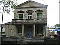
The Island Tea Rooms Garden, Midsomer Norton
Black Necked Swans (obviously!)
Image: © Nigel Shoosmith
Taken: 12 May 2007
0.15 miles
4
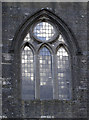
Reflecting glory
Sun and cloud in the window of St John the Baptist. See Image] for the church.
Image: © Neil Owen
Taken: 14 Feb 2013
0.15 miles
5
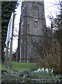
Spring in bloom
Snowdrops in the grounds of St John the Baptist. See Image] for a benchmark and Image] for some light on the window.
Image: © Neil Owen
Taken: 14 Feb 2013
0.15 miles
6
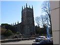
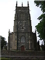
The church of St John the Baptist, Midsomer Norton
Image: © Peter Wood
Taken: 14 Mar 2013
0.16 miles
7
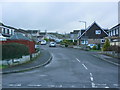
2009 : Millfield, continuing to Laburnum Grove
Part of a housing development to the south of Midsomer Norton.
Image: © Maurice Pullin
Taken: 16 Jan 2009
0.16 miles
8
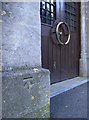
Benchmark welcoming the worshippers to St John
A cutmark, as listed in the Benchmark Database: http://www.bench-marks.org.uk/bm47341 , by the door to St John the Baptist, Midsomer Norton. See Image] for a look at the church from the grounds.
Image: © Neil Owen
Taken: 14 Feb 2013
0.16 miles
9
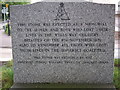
Miners Memorial, Midsomer Norton
Memorial commemorating the Wells Way Colliery Disaster of 1839, situated in St. Johns churchyard.
Image: © Nigel Shoosmith
Taken: 12 May 2007
0.17 miles