IMAGES TAKEN NEAR TO
Wells Road, BATH, BA2 9AY
Introduction
This page details the photographs taken nearby to Wells Road, BA2 9AY by members of the Geograph project.
The Geograph project started in 2005 with the aim of publishing, organising and preserving representative images for every square kilometre of Great Britain, Ireland and the Isle of Man.

There are currently over 7.5m images from over14,400 individuals and you can help contribute to the project by visiting https://www.geograph.org.uk
Image Map
Images are licensed for reuse under creativecommons.org/licenses/by-sa/2.0
Notes
- Clicking on the map will re-center to the selected point.
- The higher the marker number, the further away the image location is from the centre of the postcode.
Image Listing (44 Images Found)
Images are licensed for reuse under creativecommons.org/licenses/by-sa/2.0
Image
Details
Distance
1

2008 : The A39 at Corston
Looking toward Bath.
Image: © Maurice Pullin
Taken: 8 Sep 2008
0.02 miles
2
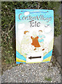
F?te today!
Sign proclaiming the village's annual celebration on the playing fields.
Image: © Neil Owen
Taken: 16 Jul 2011
0.04 miles
3
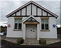
Village Hall, Corston
Built in 1913. Don't be mislead, it is quite deep!!
Full details http://listomaniabath.com/places/corston-village-hall/
Image: © Rick Crowley
Taken: 9 Oct 2016
0.05 miles
4
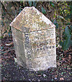
Parish Boundary Stone
The Bath Turnpike's Newton/Corston Parish Boundary Stone. The Turnpike Act stated that boundary stones were to be erected where a parish boundary crossed a Turnpike road.
Image: © Rick Crowley
Taken: 21 Feb 2010
0.05 miles
5

Corston village sign with the church behind
View of All Saints church from the edge of the village
Image: © MJ Reilly
Taken: 31 Mar 2008
0.06 miles
6
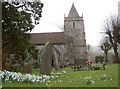
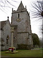
All Saints Church, Corston
A view of this ancient place of worship, with snowdrops in bloom.
See also Image
Image: © Neil Owen
Taken: 18 Feb 2011
0.07 miles
7
All Saints Church, Corston
There is documentary evidence of a church here at Corston since 1180 when 'Abel the Priest' is noted as Parson. Earlier Saxon records indicate there may have been an church on this site as it confirms a gift of land at Corston from King Edmund to the Abbots of Bath a century before. The tower seen here remains largely untouched from the 1620's.
See http://www.allsaintscorston.org.uk/History.htm for more about this charming old village church.
See Image] for the view of the benchmark on the tower, Image] for a view of the grounds.
Image: © Neil Owen
Taken: 18 Feb 2011
0.07 miles
8

Cut benchmark on All Saints Church, Corston
Situated on the left hand corner of the church tower, the OS Database gives the date of levelling as 1956, at a height above Newlyn sea level as 40.4805 (second order).
See Image] and Image] for views of the church, and http://www.bench-marks.org.uk/bm37071 for the Benchmark Database.
Image: © Neil Owen
Taken: 18 Feb 2011
0.07 miles
9
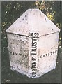
Old Boundary Marker by the A39, Wells Road, Corston
Parish Boundary Marker - Turnpike by the A39, in parish of Corston (Bath And North East Somerset District), eastern side of Corston Village, on grass verge beside the South side of the road.
Inscription reads:-
: NEWTON : : 1827 / TURNPIKE TRUST : : CORSTON :
Grade II listed.
List Entry Number: 1320799 https://historicengland.org.uk/listing/the-list/list-entry/1320799
Surveyed.
Milestone Society National ID: SO_BAMK03pb
Image: © Milestone Society
Taken: Unknown
0.07 miles
10
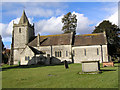
All Saints Church Corston, Somerset
Taken from the South
Image: © Rick Crowley
Taken: 21 Feb 2010
0.08 miles