IMAGES TAKEN NEAR TO
Lower Peasedown, BATH, BA2 8AJ
Introduction
This page details the photographs taken nearby to Lower Peasedown, BA2 8AJ by members of the Geograph project.
The Geograph project started in 2005 with the aim of publishing, organising and preserving representative images for every square kilometre of Great Britain, Ireland and the Isle of Man.

There are currently over 7.5m images from over14,400 individuals and you can help contribute to the project by visiting https://www.geograph.org.uk
Image Map
Images are licensed for reuse under creativecommons.org/licenses/by-sa/2.0
Notes
- Clicking on the map will re-center to the selected point.
- The higher the marker number, the further away the image location is from the centre of the postcode.
Image Listing (14 Images Found)
Images are licensed for reuse under creativecommons.org/licenses/by-sa/2.0
Image
Details
Distance
1
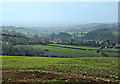
2008 : The Cam Brook Valley
From a cornfield north of Peasedown we are looking due west along the valley of the Cam Brook. It is possible to see a few buildings south of Timsbury on the right hand edge about 3/4 of the way up.
This valley was at the heart of the North Somerset coalfield and was serviced by the Somerset Coal Canal running at its foot as far as Radford Basin until the railway made it unprofitable. Parts of the line can still be found.
Image: © Maurice Pullin
Taken: 1 Apr 2008
0.15 miles
2
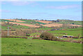
Off Firgrove Lane
Looking across fields towards Splott Farm.
Image: © Wayland Smith
Taken: 2 Apr 2021
0.18 miles
3
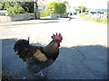
It's an old question
The chicken was one of several that were roaming free on the quiet roads hereabouts, calmly and serenely exploring for morsels. There was a moment to pose the obvious; he stopped for a short pause but said he had other plots to hatch.
Image: © Neil Owen
Taken: 24 May 2022
0.20 miles
4
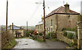
Houses at Carlingcott
The house on the left is at the junction of Stoneage Lane (left) with Withyditch Lane.
Image: © Derek Harper
Taken: 6 Dec 2019
0.22 miles
5
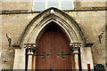
United Methodist Free Church, Carlingcott
The listed building description includes: "a thin pointed porch on colonettes with leaf capitals, it bears the text United Methodist Free Church, 1851" https://historicengland.org.uk/listing/the-list/list-entry/1129506 . See also Image
Image: © Derek Harper
Taken: 6 Dec 2019
0.22 miles
6
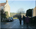
2009 : Carlingcott looking east
A small group out for a Sunday morning stroll - er - slide. Keeping well into the side of the road to avoid the ice in the middle.
Alpenstocks would have been useful.
Image: © Maurice Pullin
Taken: 20 Dec 2009
0.23 miles
7
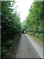
From the coal statue to the coal canal (24)
Van heading towards Carlingcott
Image: © Basher Eyre
Taken: 14 Sep 2013
0.23 miles
8
From the coal statue to the coal canal (22)
Traffic jam in Carlingcott
Image: © Basher Eyre
Taken: 14 Sep 2013
0.23 miles
9
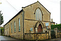
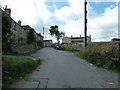
United Methodist Free Church, Carlingcott
"Chapel and schoolroom. Dated 1851" begins the listed building description https://historicengland.org.uk/listing/the-list/list-entry/1129506 . The walls and gates at the front form part of the listing. Now for sale, as you can see, although the agent seems to think it dates from 1869. However, I can confirm that the date on the "thin pointed porch on colonettes with leaf capitals" is 1851. On the left is Firgrove Lane, heading to Peasedown St John.
Image: © Derek Harper
Taken: 6 Dec 2019
0.23 miles
10
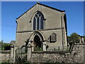
Carlingcott Methodist church
The building was founded in 1851, along with a schoolroom, as a United Free Methodist church. They faced some competition not far up the road in the form of a Wesleyan chapel. The Free church later became the Carlingcott Methodist chapel, before closure a few years ago. The church, its attached gates, piers and flanking walls are Grade II listed.
Image: © Neil Owen
Taken: 24 May 2022
0.23 miles