IMAGES TAKEN NEAR TO
Midford, BATH, BA2 7BY
Introduction
This page details the photographs taken nearby to BA2 7BY by members of the Geograph project.
The Geograph project started in 2005 with the aim of publishing, organising and preserving representative images for every square kilometre of Great Britain, Ireland and the Isle of Man.

There are currently over 7.5m images from over14,400 individuals and you can help contribute to the project by visiting https://www.geograph.org.uk
Image Map
Images are licensed for reuse under creativecommons.org/licenses/by-sa/2.0
Notes
- Clicking on the map will re-center to the selected point.
- The higher the marker number, the further away the image location is from the centre of the postcode.
Image Listing (119 Images Found)
Images are licensed for reuse under creativecommons.org/licenses/by-sa/2.0
Image
Details
Distance
1
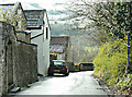
2008 : Midford, looking south east
Down the hill from the crossroads. The B3110 is at the bottom with the two disused railway bridges.
Image: © Maurice Pullin
Taken: 6 Apr 2008
0.02 miles
2
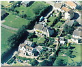
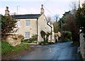
Midford Houses
"Old Post Office" (top house left), "Fairly" (middle) Old Wesleyan Chapel (small building) "White Cottage" (bottom)
Image: © Graeme Kitney
Taken: Unknown
0.03 miles
3
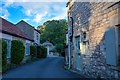
Midford : Tucking Mill Lane
A road heading through a small hamlet.
Image: © Lewis Clarke
Taken: 6 Aug 2020
0.03 miles
4
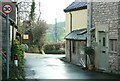
2008 : Crossroads at Old Midford
Thousands of people per week pass along the B3110 between Bath and Wolverton. There are probably less than 50 who see this scene and the locals are very pleased.
Image: © Maurice Pullin
Taken: 6 Apr 2008
0.03 miles
5
2008 : Crossroads on Old Midford Road
This was the main road through Midford before the Bath to Wolverton road, now the B3110, was built. The lane to the right goes to Combe Hay after crossing the B3110, to the left we find Monkton Combe and straight on for Bath.
Image: © Maurice Pullin
Taken: 6 Apr 2008
0.04 miles
6
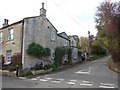
Crossroads in Midford
This is the central point of the village. The house on the corner has had an upper room built as an extension, with an oval window.
Image: © HelenK
Taken: 14 Nov 2013
0.05 miles
7
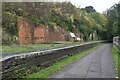
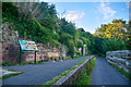
Disused railway station platform at Midford
The path is the southern end of the Two Tunnels Greenway, on the route of the former Somerset and Dorset Joint Railway. The line and station closed in 1966. For the view below the line to the right, see Image
Image: © David Martin
Taken: 24 Oct 2024
0.06 miles
8
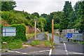
Midford : Two Tunnels Greenway
A footpath heading from Midford towards Bath.
Image: © Lewis Clarke
Taken: 6 Aug 2020
0.06 miles
9
Midford : Two Tunnels Greenway
Passing the site of the former Midford Station.
Image: © Lewis Clarke
Taken: 6 Aug 2020
0.06 miles
10
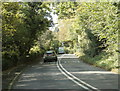
2009 : B3110 Midford Road starting the climb from Midford
On the way to Bath.
Very busy at certain times as it forms part of a route round the south of Bath avoiding the city centre.
Image: © Maurice Pullin
Taken: 8 Oct 2009
0.06 miles