IMAGES TAKEN NEAR TO
Henrietta Gardens, BATH, BA2 6NA
Introduction
This page details the photographs taken nearby to Henrietta Gardens, BA2 6NA by members of the Geograph project.
The Geograph project started in 2005 with the aim of publishing, organising and preserving representative images for every square kilometre of Great Britain, Ireland and the Isle of Man.

There are currently over 7.5m images from over14,400 individuals and you can help contribute to the project by visiting https://www.geograph.org.uk
Image Map
Images are licensed for reuse under creativecommons.org/licenses/by-sa/2.0
Notes
- Clicking on the map will re-center to the selected point.
- The higher the marker number, the further away the image location is from the centre of the postcode.
Image Listing (312 Images Found)
Images are licensed for reuse under creativecommons.org/licenses/by-sa/2.0
Image
Details
Distance
1
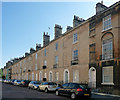
1-18 Daniel Street, Bath
A modest but attractive terrace of three-storey houses, a single broad window to each floor. Those to the first floor are set in a blind arch. By John Pinch the Elder, 1810. Grade II listed.
Image: © Stephen Richards
Taken: 25 May 2012
0.03 miles
2

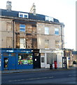
Best Sunday Paper
This metal advertisement is now (like many old advertisements in Bath) obsolete, as the final edition of the News of the World appeared the previous Sunday.
[2018 update: the Bathwick News newsagent in Daniel Mews became obsolete a few years later. The premises are now a house.]
Image: © HelenK
Taken: 15 Jul 2011
0.04 miles
3
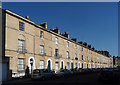
19-36 Daniel Street, Bath
A modest but attractive terrace of three-storey houses, a single broad window to each floor. The lower ones are set in a blind arch. Begun by Thomas Baldwin, c1792, but mostly by John Pinch the Elder, 1810, after Baldwin was declared bankrupt. Grade II listed.
Image: © Stephen Richards
Taken: 25 May 2012
0.04 miles
4

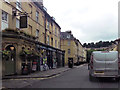
Bath : Daniel Street
Looking along Daniel Street from Sutton Street.
Image: © Lewis Clarke
Taken: 6 Aug 2020
0.05 miles
5
December sunshine and shadow in Bath
Daniel Street in sunshine, Bathwick Street in shadow, early afternoon in December 2012.
Image: © Jaggery
Taken: 10 Dec 2012
0.05 miles
6
Former Bathwick Street post office, Bath
The white building on the corner of Daniel Street retains
the post office name above the doorway, but the post office has gone.
Image: © Jaggery
Taken: 10 Dec 2012
0.05 miles
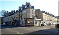
8
The Barley Mow, Bath
Pub at 32 Bathwick Street, on the corner of Daniel Mews.
Image: © Jaggery
Taken: 10 Dec 2012
0.06 miles
9
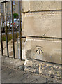
Benchmark in a pub wall
A nice cut mark on the wall of the Pulteney Arms pub in Daniel Street. See http://www.bench-marks.org.uk/bm37814 for the Benchmark Database and Image] for a general view.
The row of markers continue along the length of the wall but don't seem to have an explanation. Could they mark a flood level of times past?
Image: © Neil Owen
Taken: 21 Apr 2011
0.06 miles
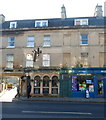
10

The Pulteney Arms, as seen from Sutton Street
An old pub, open since about 1759, with strong roots in local rugby. Visit their website - http://www.thepulteneyarms.co.uk/.
See Image] for the benchmark that is located on the short wall below the sign.
Image: © Neil Owen
Taken: 21 Apr 2011
0.06 miles