IMAGES TAKEN NEAR TO
Kilkenny Lane, BATH, BA2 2SJ
Introduction
This page details the photographs taken nearby to Kilkenny Lane, BA2 2SJ by members of the Geograph project.
The Geograph project started in 2005 with the aim of publishing, organising and preserving representative images for every square kilometre of Great Britain, Ireland and the Isle of Man.

There are currently over 7.5m images from over14,400 individuals and you can help contribute to the project by visiting https://www.geograph.org.uk
Image Map
Images are licensed for reuse under creativecommons.org/licenses/by-sa/2.0
Notes
- Clicking on the map will re-center to the selected point.
- The higher the marker number, the further away the image location is from the centre of the postcode.
Image Listing (27 Images Found)
Images are licensed for reuse under creativecommons.org/licenses/by-sa/2.0
Image
Details
Distance
1
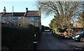
Rose Cottages, Kilkenny Lane
The lane passes a terrace of four cottages at right angles to it.
Image: © Derek Harper
Taken: 16 Feb 2016
0.02 miles
2
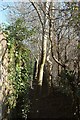
Footpath, Odd Down
A tiny path that links the Odd Down roundabout to Kilkenny Lane. Not much room to squeeze past the trees.
Image: © Derek Harper
Taken: 16 Feb 2016
0.03 miles
4
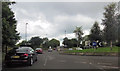
Odd Down roundabout
On the A367 by one of Bath's Park and Ride car parks, and close to where the Fosse Way and the Wansdyke cross each other. The line of the Fosse is preserved by the bit of cut-off road on the left. The new building across the roundabout on the left is The New Sixth.
Image: © Derek Harper
Taken: 16 Feb 2016
0.05 miles
5
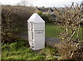
Turnpike marker near the Wansdyke
A familiar cast iron boundary marker from the turnpike era, overlooking the countryside around the older Wansdyke.
Image: © Neil Owen
Taken: 17 Jan 2018
0.05 miles
6
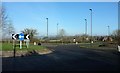
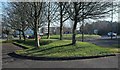
Odd Down roundabout
The A367, along the line of the Fosse Way, leaves the roundabout ahead on its way into Bath.
Image: © Derek Harper
Taken: 16 Feb 2016
0.06 miles
7

Old Boundary Marker on Roman Road
Turnpike Parish Boundary Marker on the northwest side of the A367 Roman Road northeast of the roundabout at the entrance to the Odd Down Park and Ride. In the parish of Combe Hay (Bath and North East Somerset District).
Inscription reads:-
: COMBEHAY : : 1827 / BATH TURNPIKE TRUST : : ENGLISH / COMBE :
Grade II listed.
List Entry Number: 1313025 https://historicengland.org.uk/listing/the-list/list-entry/1313025
Surveyed
Milestone Society National ID: SO_BARA02pb
Image: © Milestone Society
Taken: 4 Aug 2002
0.06 miles
8
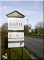
Proud heritage
Welcome to a World Heritage city! Located on Roman Road - the old Fosse Way in fact.
Image: © Neil Owen
Taken: 17 Jan 2018
0.06 miles
9

One stone on top of another
Some slow-paced construction on site today.
Image: © Neil Owen
Taken: 17 Jan 2018
0.06 miles
10
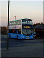
Park and Ride
The Park and Ride bus waits to take shoppers into the City of Bath
Image: © J Tucker
Taken: 4 Nov 2006
0.09 miles