IMAGES TAKEN NEAR TO
Bridle Way, YEOVIL, BA22 9TW
Introduction
This page details the photographs taken nearby to Bridle Way, BA22 9TW by members of the Geograph project.
The Geograph project started in 2005 with the aim of publishing, organising and preserving representative images for every square kilometre of Great Britain, Ireland and the Isle of Man.

There are currently over 7.5m images from over14,400 individuals and you can help contribute to the project by visiting https://www.geograph.org.uk
Image Map
Images are licensed for reuse under creativecommons.org/licenses/by-sa/2.0
Notes
- Clicking on the map will re-center to the selected point.
- The higher the marker number, the further away the image location is from the centre of the postcode.
Image Listing (15 Images Found)
Images are licensed for reuse under creativecommons.org/licenses/by-sa/2.0
Image
Details
Distance
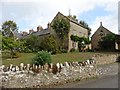
2
Barwick: Barwick Mill
This was a water-powered flax and tow mill established by 1808. By the late nineteenth century it was used for milling grain. In the twenty-first century it has been converted to housing.
Image: © Martin Bodman
Taken: 20 Aug 2012
0.10 miles
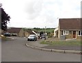
4
System Built Houses, Stoford
These unusual two storey semi-detached system built houses are located on Fairhouse Rd, Stoford. There is another pair just around the corner on Bullen Rd. There are also some identical houses in the centre of Yeovil a few miles away. These are a form of Nissen-Petren house which were designed and built in Yeovil around 1925.
Image: © Nigel Mykura
Taken: 16 Jan 2015
0.12 miles
5
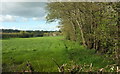
Towards Stoford
From the A37 at Key Bridge, which is over a tributary of the Sutton Bingham Stream that follows the trees on the right. The houses in the distance are in Image
Image: © Derek Harper
Taken: 27 Apr 2019
0.16 miles
6
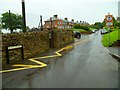
The Orange Way in Dorset and Somerset (144)
Go this way through Barwick.
Image: © Shazz
Taken: 7 Jul 2012
0.19 miles
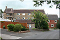
7
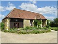
Court House Barn
The converted barn is used for charity events, small celebrations, meetings and a place to go for moments of quietness. There is also a memorial field with trees planted in remembrance of loved ones.
Image: © Sarah Smith
Taken: 3 Jun 2023
0.19 miles
8
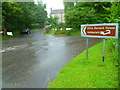
The Orange Way in Dorset and Somerset (143)
The Orange Way turns right at the end of Church Lane.
Image: © Shazz
Taken: 7 Jul 2012
0.20 miles
9

Barwick: postbox № BA22 191, Rexe?s Hollow Lane
This Elizabeth II-reign (pre-1994) postbox is strapped to a concrete post and emptied at noon on weekdays and at 9am on Saturdays.
The name Rexe's Hollow Lane is a bit of an inconsistency - it is Rex's Lane on large-scale mapping including my street atlas, while the street sign gives Rexes Hollow Lane. The OS 1:25,000 map does give Rexe's Hollow as a name for the route, giving the slightly surprisingly positioned possessive apostrophe.
Image: © Chris Downer
Taken: 14 Jul 2014
0.21 miles
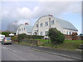
10
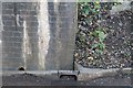
Benchmark on Railway Bridge, Stoford
Ordnance Survey benchmark, described on database at http://www.bench-marks.org.uk/bm63674. See also http://www.geograph.org.uk/photo/4317932.
Image: © Becky Williamson
Taken: 19 Jan 2015
0.21 miles