IMAGES TAKEN NEAR TO
High Street, YEOVIL, BA22 9AU
Introduction
This page details the photographs taken nearby to High Street, BA22 9AU by members of the Geograph project.
The Geograph project started in 2005 with the aim of publishing, organising and preserving representative images for every square kilometre of Great Britain, Ireland and the Isle of Man.

There are currently over 7.5m images from over14,400 individuals and you can help contribute to the project by visiting https://www.geograph.org.uk
Image Map
Images are licensed for reuse under creativecommons.org/licenses/by-sa/2.0
Notes
- Clicking on the map will re-center to the selected point.
- The higher the marker number, the further away the image location is from the centre of the postcode.
Image Listing (21 Images Found)
Images are licensed for reuse under creativecommons.org/licenses/by-sa/2.0
Image
Details
Distance
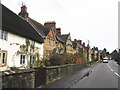
1
#96 High Street ('Mill Cottage') beside the A30
There is an OS benchmark Image on the roadface of the near corner of the building, right of the verge marker
Image: © Roger Templeman
Taken: 24 Sep 2013
0.00 miles
2
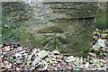
Benchmark on Mill Cottage (#96 High Street)
Ordnance Survey cut mark benchmark described on the Bench Mark Database at http://www.bench-marks.org.uk/bm51616
Image: © Roger Templeman
Taken: 24 Sep 2013
0.01 miles
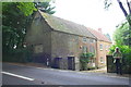
4
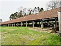
Dawe's Twineworks West Coker
Rescued from near collapse by grant money, the twineworks, established in the mid 19th C, is the only one in Britain with its original Victorian machinery. Not to be confused with the West of England Twine Works which was also situated in West Coker.
Open on the 4th Saturday of the month.
Image: © Sarah Smith
Taken: 22 Jan 2022
0.05 miles
5

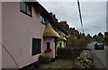
West Coker : The Cottage, 90 High Street
The cottage at 90 High Street with hedgerow and grassy garden in view. Local stone rubble with Ham stone dressings; clay pantiles between stepped coped gables; brick end chimney stacks.
Image: © Lewis Clarke
Taken: 16 Mar 2012
0.05 miles
6

West Coker High Street
West Coker High Street was once on the London to Penzance trunk road.
Canvas was produced here for the Royal Navy and called Coker canvas.
Image: © John Barnes
Taken: 9 Nov 2001
0.09 miles
7
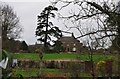
West Coker : Millbrook Cottage
A cottage on the High Street in West Coker. Rendered and colourwashed; thatched roof between coped gables; brick end chimney stacks. Two-storeys, Two-bays. Timber casement windows: rendered porch with arched side openings, thatched roof, framing a boarded door. Interior not seen. Attached on East side No.86.
Image: © Lewis Clarke
Taken: 16 Mar 2012
0.10 miles
8
West Coker : Wash House
Wash House (also known as The Wash, formerly listed as Wash Farmhouse No 102 High Street).
Image: © Lewis Clarke
Taken: 16 Mar 2012
0.13 miles
9

The Castle Pub West Coker
A fire destroyed the roof recently, http://www.thisissomerset.co.uk/West-Coker-pub-spread-quickly-wind-blew/story-18677140-detail/story.html#axzz2QGJyMXE1
Image: © John Firth
Taken: 12 Apr 2013
0.14 miles