IMAGES TAKEN NEAR TO
Lower Odcombe, YEOVIL, BA22 8TY
Introduction
This page details the photographs taken nearby to BA22 8TY by members of the Geograph project.
The Geograph project started in 2005 with the aim of publishing, organising and preserving representative images for every square kilometre of Great Britain, Ireland and the Isle of Man.

There are currently over 7.5m images from over14,400 individuals and you can help contribute to the project by visiting https://www.geograph.org.uk
Image Map
Images are licensed for reuse under creativecommons.org/licenses/by-sa/2.0
Notes
- Clicking on the map will re-center to the selected point.
- The higher the marker number, the further away the image location is from the centre of the postcode.
Image Listing (44 Images Found)
Images are licensed for reuse under creativecommons.org/licenses/by-sa/2.0
Image
Details
Distance

2

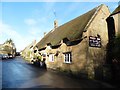
Lower Odcombe
The lower part of the village is just to the north of the ridge that forms ham Hill. This is the view along the main street of the lower village on the very east of the square.
Image: © Nigel Mykura
Taken: 1 May 2009
0.10 miles

4
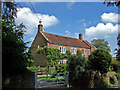
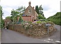
Bank Farmhouse - Lower Odcombe
Grade II listed former farmhouse dating from the C17, and partly reconstructed after a fire in C19.
Image: © Mike Searle
Taken: 24 May 2007
0.12 miles
6
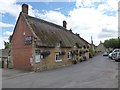
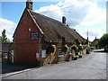
The Masons Arms, Lower Odcombe
A thriving pub after nearly closing in 2005. Also has a Caravan Park to the rear.
Image: © Steve Barnes
Taken: 21 Aug 2011
0.13 miles
8
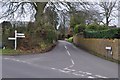
Odcombe : Lower Odcombe
A road called Lower Odcombe at the junction with Old Road.
Image: © Lewis Clarke
Taken: 16 Mar 2012
0.15 miles
9
Junction at Odcombe
Part of a junction of five lanes at Donnlane Head, though only four are motorable. on the left is Dray Road; on the right is Boundhay.
Image: © Derek Harper
Taken: 9 Jun 2010
0.15 miles
10
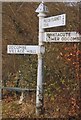
Old Direction Sign - Signpost by Old Road, Lower Odcombe, Odcombe Parish
Pyramid finial - 3 arms; Somerset pointing fingers by the UC road, in parish of Odcombe (South Somerset District), Lower Odcombe.
Surveyed
Milestone Society National ID: SO_ST5115
Image: © Milestone Society
Taken: Unknown
0.16 miles