IMAGES TAKEN NEAR TO
Tintinhull Road, YEOVIL, BA22 8QX
Introduction
This page details the photographs taken nearby to Tintinhull Road, BA22 8QX by members of the Geograph project.
The Geograph project started in 2005 with the aim of publishing, organising and preserving representative images for every square kilometre of Great Britain, Ireland and the Isle of Man.

There are currently over 7.5m images from over14,400 individuals and you can help contribute to the project by visiting https://www.geograph.org.uk
Image Map
Images are licensed for reuse under creativecommons.org/licenses/by-sa/2.0
Notes
- Clicking on the map will re-center to the selected point.
- The higher the marker number, the further away the image location is from the centre of the postcode.
Image Listing (23 Images Found)
Images are licensed for reuse under creativecommons.org/licenses/by-sa/2.0
Image
Details
Distance
3
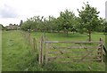
Orchard, Chilthorne Domer
According to the detailed map, footpaths Y 4/4 and Y 4/3 both pass through the orchard to reach the village street, but the map I was carrying implied that the former kept to the left of the fence, which is what I did.
Image: © Derek Harper
Taken: 9 Jun 2010
0.16 miles
4
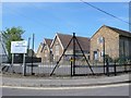
Chilthorne Domer Primary School
The school is situated at the southern end of the village on the corner of the junction of Main St and the Tintinhull Rd from Yeovil
Image: © Nigel Mykura
Taken: 21 Apr 2009
0.17 miles
5
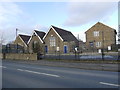
Chilthorne Domer Primary School
The school occupies an old house on the right, two old school buildings in the centre and a new building sympathetically matching the old ones on the left. It sits at the junction of Chilthorne Domer main St and the Tintinhull Rd.
Image: © Nigel Mykura
Taken: 30 Jan 2016
0.17 miles
6
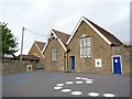
Chilthorne Domer School
There is an Ordnance Survey benchmark on this school. See Image
Image: © Becky Williamson
Taken: 28 Jul 2015
0.17 miles
7
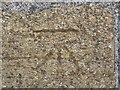
Benchmark on Chilthorne Domer School
Ordnance Survey benchmark, described on database at http://www.bench-marks.org.uk/bm69264. See also Image
Image: © Becky Williamson
Taken: 28 Jul 2015
0.17 miles
8
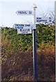
Direction Sign - Signpost at the junction of Tintinhull Road and Main Street
Pyramid finial - 3 arms; Somerset SCC pyramid by the UC road, in parish of Brympton (South Somerset District), on the south side of the T junction of Tintinhull Road and Main Street.
Surveyed
Milestone Society National ID: SO_ST5218
Image: © Milestone Society
Taken: Unknown
0.18 miles
9
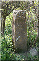
Old Boundary Marker, Tintinhull Road, Chilthorne Domer
Turnpike Terminus Marker by the UC road, in parish of Chilthorne Domer (South Somerset District), junction of Main Street with Tintinhull Road, opposite school, on verge of road in front of hedge, South side of road.
Inscription reads:-
: HERE begins Chilthorne :
Grade II listed.
List entry No.: 1345757 https://historicengland.org.uk/listing/the-list/list-entry/1345757
Surveyed
Milestone Society National ID: SO_YVTH03t
Image: © Alan Rosevear
Taken: 12 Apr 2011
0.19 miles
10

Main Street Chilthorne Domer
View south up the main street through the village about half way along.
Image: © Nigel Mykura
Taken: 21 Apr 2009
0.20 miles