IMAGES TAKEN NEAR TO
Farm Street, YEOVIL, BA22 8PZ
Introduction
This page details the photographs taken nearby to Farm Street, BA22 8PZ by members of the Geograph project.
The Geograph project started in 2005 with the aim of publishing, organising and preserving representative images for every square kilometre of Great Britain, Ireland and the Isle of Man.

There are currently over 7.5m images from over14,400 individuals and you can help contribute to the project by visiting https://www.geograph.org.uk
Image Map
Images are licensed for reuse under creativecommons.org/licenses/by-sa/2.0
Notes
- Clicking on the map will re-center to the selected point.
- The higher the marker number, the further away the image location is from the centre of the postcode.
Image Listing (117 Images Found)
Images are licensed for reuse under creativecommons.org/licenses/by-sa/2.0
Image
Details
Distance
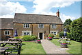
1
![Tintinhull houses [1]](https://s0.geograph.org.uk/geophotos/07/53/30/7533048_433a810c_120x120.jpg)
Tintinhull houses [1]
Numbers 9 and 11 Farm Street are two 18th century cottages, extended in the 19th century and altered in the 20th century. Constructed of squared Ham stone with ashlar dressings under a pantile roof. Listed, grade II, with details at: https://historicengland.org.uk/listing/the-list/list-entry/1235111
Tintinhull is a village in Somerset, some 4¼ miles northwest of Yeovil and about 17¼ miles southeast of Taunton. Originally an agricultural village with the surrounding landscape containing evidence of 2,000 years of farming, however, most working residents now commute. Mentioned in the Domesday Book, the village is home to the 17th century Tintinhull House and Gardens.
Image: © Michael Dibb
Taken: 19 May 2023
0.02 miles
2
The Crown and Victoria, Tintinhull
The beer garden is the perfect place to relax after a visit to Tintinhull House and Garden just over the road. Real ale served and child friendly.
Image: © Bill Harrison
Taken: 14 Jul 2016
0.03 miles
3
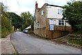
The Crown and Victoria Inn, Farm Street, Tintinhull, Somerset
Image: © Derek Voller
Taken: 29 Sep 2017
0.03 miles
5
The Crown and Victoria Inn, Farm Street, Tintinhull, Somerset
Image: © Derek Voller
Taken: 29 Sep 2017
0.03 miles
6

Houses in Farm Street, Tintinhull, Somerset
Image: © Derek Voller
Taken: 29 Sep 2017
0.03 miles
7
![Tintinhull buildings [1]](https://s2.geograph.org.uk/geophotos/07/53/30/7533054_e70045dc_120x120.jpg)
Tintinhull buildings [1]
Adjacent to Lamb Farmhouse Image is this outbuilding, possibly a former forge, probably built in the 19th century. Constructed of coursed Ham stone rubble under a double Roman tile roof. Listed, grade II, with details at: https://historicengland.org.uk/listing/the-list/list-entry/1235188
Tintinhull is a village in Somerset, some 4¼ miles northwest of Yeovil and about 17¼ miles southeast of Taunton. Originally an agricultural village with the surrounding landscape containing evidence of 2,000 years of farming, however, most working residents now commute. Mentioned in the Domesday Book, the village is home to the 17th century Tintinhull House and Gardens.
Image: © Michael Dibb
Taken: 19 May 2023
0.03 miles
9

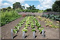
Through the arch in the hedge, Tintinhull Gardens
Image: © Derek Voller
Taken: 29 Sep 2017
0.04 miles
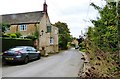
10
![Tintinhull houses [2]](https://s0.geograph.org.uk/geophotos/07/53/30/7533052_25d8dd2d_120x120.jpg)
Tintinhull houses [2]
Lamb Farmhouse, number 2 Farm Street, is a 17th century detached farmhouse with later alterations. Constructed of Ham stone ashlar on a rubble plinth under a Welsh slate roof. On the right is a small lean-to. Outside the door is a cast iron pump with a small stone bowl. Listed, grade II, with details at: https://historicengland.org.uk/listing/the-list/list-entry/1265232
Tintinhull is a village in Somerset, some 4¼ miles northwest of Yeovil and about 17¼ miles southeast of Taunton. Originally an agricultural village with the surrounding landscape containing evidence of 2,000 years of farming, however, most working residents now commute. Mentioned in the Domesday Book, the village is home to the 17th century Tintinhull House and Gardens.
Image: © Michael Dibb
Taken: 19 May 2023
0.04 miles