IMAGES TAKEN NEAR TO
Wedmore Park, BATH, BA2 1LA
Introduction
This page details the photographs taken nearby to Wedmore Park, BA2 1LA by members of the Geograph project.
The Geograph project started in 2005 with the aim of publishing, organising and preserving representative images for every square kilometre of Great Britain, Ireland and the Isle of Man.

There are currently over 7.5m images from over14,400 individuals and you can help contribute to the project by visiting https://www.geograph.org.uk
Image Map
Images are licensed for reuse under creativecommons.org/licenses/by-sa/2.0
Notes
- Clicking on the map will re-center to the selected point.
- The higher the marker number, the further away the image location is from the centre of the postcode.
Image Listing (47 Images Found)
Images are licensed for reuse under creativecommons.org/licenses/by-sa/2.0
Image
Details
Distance
1

'High View'
Colour image of the park bench at the top of Roundhill (Twerton Roundhill) Bath.
With the overhead, cloud diffused morning 'light' at the top of the image.
More detailed 'dark' at the bottom of the image, distant horizon in the middle.
A simple image, seen while passing by on the 'level' after climbing the slope.
Image: © D M Wilmot
Taken: 16 Jan 2022
0.09 miles
2
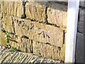
Ordnance Survey Cut Mark
This OS cut mark can be found on No149 Whiteway. It marks a point 116.687m above mean sea level.
Image: © Adrian Dust
Taken: 2 Dec 2022
0.10 miles
3
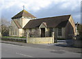
Southdown Methodist Church
A view looking east across The Hollow, towards the Methodist Church at Southdown.
Image: © Phil Williams
Taken: 9 Mar 2007
0.11 miles
4
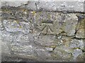
Ordnance Survey Cut Mark
This OS cut mark can be found on No161 The Hollow. It marks a point 116.259m above mean sea level.
Image: © Adrian Dust
Taken: 2 Dec 2022
0.11 miles
5
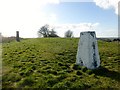
Southdown
Parked on pavement of main road then a short walk uphill to bag the trig and nearby summit.
Name: Southdown
Hill number: 18215
Height: 141m / 463ft
Parent (Ma/M): 2891 Beacon Batch
Section: 41: South Central England
County/UA: Bath and NE Somerset (CoU)
Class: Unclassified
Grid ref: ST724633 (est)
Drop: 27m
Col: 114m ST726630
Image: © Rude Health
Taken: 26 Mar 2015
0.11 miles
6
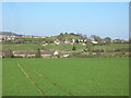
Southdown from the Byway south of Englishcombe
Image: © James Ayres
Taken: 17 Apr 2010
0.11 miles
7

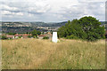
Trig Point 6624 Twerton Hill
A multicoloured trig point, fine views to the south
Image: © Damon Knight
Taken: 13 Jan 2007
0.12 miles
8
Twerton Roundhill in Bath
Trig point still in evidence.
Image: © Rick Crowley
Taken: 17 Jul 2010
0.12 miles
9

Southdown Methodist Church Centre
The nearby Methodist church in Oldfield Park closed a few years ago, but the church remains active in the area at this complex of church buildings.
Image: © HelenK
Taken: 14 Sep 2013
0.12 miles
10
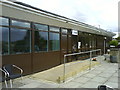
Cafe Linden in Hilliers Garden Centre
Image: © Steve Daniels
Taken: 18 Aug 2010
0.12 miles