IMAGES TAKEN NEAR TO
Mudford, YEOVIL, BA21 5SW
Introduction
This page details the photographs taken nearby to BA21 5SW by members of the Geograph project.
The Geograph project started in 2005 with the aim of publishing, organising and preserving representative images for every square kilometre of Great Britain, Ireland and the Isle of Man.

There are currently over 7.5m images from over14,400 individuals and you can help contribute to the project by visiting https://www.geograph.org.uk
Image Map
Images are licensed for reuse under creativecommons.org/licenses/by-sa/2.0
Notes
- Clicking on the map will re-center to the selected point.
- The higher the marker number, the further away the image location is from the centre of the postcode.
Image Listing (4 Images Found)
Images are licensed for reuse under creativecommons.org/licenses/by-sa/2.0
Image
Details
Distance
1
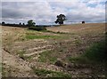
Fields beside Sock Lane
A shallow valley runs northeastwards away from the lane between Mudford Sock and Sock Hill. Cold Brook has its source at the beginning of the bushes in the centre.
Image: © Derek Harper
Taken: 30 Aug 2007
0.05 miles
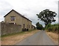
3
Countryside near Mudford Sock
View north from the lane that leads from the A359 north of Yeovil westwards to Mudford Sock on a dreary grey january day.
Image: © Nigel Mykura
Taken: 14 Jan 2010
0.19 miles
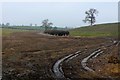
4
Field on Sock Hill
A large field, complete with rectangular haystack (strawstack?), which drops towards Cold Brook, seen from Droveway Lane, a track followed by the Monarch's Way.
Image: © Derek Harper
Taken: 30 Aug 2007
0.23 miles