IMAGES TAKEN NEAR TO
Sherborne Road, YEOVIL, BA21 5BG
Introduction
This page details the photographs taken nearby to Sherborne Road, BA21 5BG by members of the Geograph project.
The Geograph project started in 2005 with the aim of publishing, organising and preserving representative images for every square kilometre of Great Britain, Ireland and the Isle of Man.

There are currently over 7.5m images from over14,400 individuals and you can help contribute to the project by visiting https://www.geograph.org.uk
Image Map
Images are licensed for reuse under creativecommons.org/licenses/by-sa/2.0
Notes
- Clicking on the map will re-center to the selected point.
- The higher the marker number, the further away the image location is from the centre of the postcode.
Image Listing (85 Images Found)
Images are licensed for reuse under creativecommons.org/licenses/by-sa/2.0
Image
Details
Distance
1
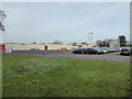
Pittards leather works, Yeovil
A modern factory on the outskirts of town. At some point Pittards had moved from closer to the town centre to this site. The company also once operated a W H Allen high speed enclosed steam generator but that has long gone. Steam is still generated on site as evidenced by the two chimneys. There was still a little frost on the grass.
Image: © Chris Allen
Taken: 27 Dec 2016
0.11 miles
2

Yeovil: KIA Motors
Part of the F J Chalke dealership by the A30 near Yeo Bridge
Image: © Martin Bodman
Taken: 15 Jul 2012
0.11 miles
3

Nissan showrooms, Sherborne Road, Yeovil
Image: © David Smith
Taken: 12 Feb 2016
0.12 miles
4

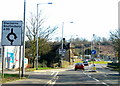
Yeovil: the A30 heading to Yeovil Bridge
By the turning into Yeobridge Trade Park. With F J Chalke, a Nissan and Kia dealer, beyond, followed by a Texaco filling station and the Yeo Bridge toll house seen in Sarah Smith's shot Image]
Image: © Martin Bodman
Taken: 15 Jul 2012
0.13 miles
5
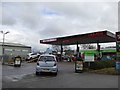
Texaco filling station, Sherborne Road, Yeovil
Image: © David Smith
Taken: 12 Feb 2016
0.13 miles
6
A30 Sherborne Road - Yeovil
The Sherborne Road reaches the roundabout and the gridline and the Dorset border just before Babylon Hill which is in the background. The stone building on the left is the Yeovil Bridge Tollhouse - please see Image
Image: © Sarah Smith
Taken: 4 Mar 2010
0.14 miles
7
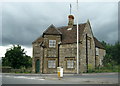
Yeovil Bridge Tollhouse
Unfortunately it is very difficult to take a photograph of the front of this building without standing in the next gridsquare as the line runs just by it. The building is built in stone and looks Victorian but is probably much older.
Image: © Sarah Smith
Taken: 2 Aug 2009
0.14 miles
8
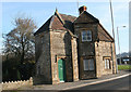
Yeovil Bridge Toll House
Toll House by the A30, in the parish of Bradford Abbas (West Dorset District), Yeovil Bridge Toll House, Sherborne Road, BA21 5BQ.
Grade II listed.
List Entry Number: 1119376 https://historicengland.org.uk/listing/the-list/list-entry/1119376
Surveyed
Milestone Society National ID: DO.BRA
Image: © Alan Rosevear
Taken: 10 Feb 2008
0.15 miles
10
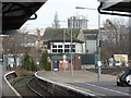
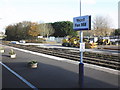
Yeovil Pen Mill Station and signal box
Image: © Chris Allen
Taken: 27 Dec 2016
0.16 miles