IMAGES TAKEN NEAR TO
Longcroft Road, YEOVIL, BA21 4RR
Introduction
This page details the photographs taken nearby to Longcroft Road, BA21 4RR by members of the Geograph project.
The Geograph project started in 2005 with the aim of publishing, organising and preserving representative images for every square kilometre of Great Britain, Ireland and the Isle of Man.

There are currently over 7.5m images from over14,400 individuals and you can help contribute to the project by visiting https://www.geograph.org.uk
Image Map (Loading...)


Getting Data...Please wait
Leaflet Map data © OpenStreetMap
Images are licensed for reuse under creativecommons.org/licenses/by-sa/2.0
Notes
- Clicking on the map will re-center to the selected point.
- The higher the marker number, the further away the image location is from the centre of the postcode.
Image Listing (27 Images Found)
Images are licensed for reuse under creativecommons.org/licenses/by-sa/2.0
Image
Details
Distance
1
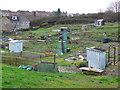
Allotments, Yeovil
These are on the eastern side of Yeovil in the most working class part of town
Image: © Nigel Mykura
Taken: 16 Jan 2008
0.05 miles
2
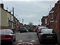
Wing Mirror Alley
Officially King Street, Yeovil this is unusually uncongested but still tight. The local car repairers do quite well out of this one road.
Image: © Steve Barnes
Taken: 19 Jul 2009
0.11 miles
3
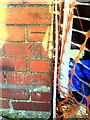
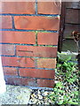
Benchmark on #132 Gold Croft
Ordnance Survey cut mark benchmark described on the Bench Mark Database at http://www.bench-marks.org.uk/bm37127
Image: © Roger Templeman
Taken: 24 Feb 2011
0.11 miles
4
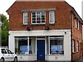
Goldcroft Awareness Centre
This building is used by various organisations for meetings and as a polling station at election time.
Image: © Steve Barnes
Taken: 19 Jul 2009
0.11 miles
5
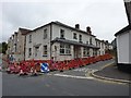
Yet another former Yeovil pub
This former public house at the intersection of Eastland and Highfield Roads is shown in the process of being converted into flats.
Image: © Steve Barnes
Taken: 12 Aug 2009
0.14 miles
6
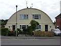
Unusual Roof Shape
Originally designed as low cost housing this unusual pair of semis actually turned out to cost more to build than the conventional houses of the time.
Image: © Steve Barnes
Taken: 19 Jul 2009
0.14 miles
7

Millford Dip
This stage of Millford Road is, for obvious reasons, known locally as Millford Dip.
Image: © Steve Barnes
Taken: 19 Jul 2009
0.15 miles
9
Benchmark on #170 Gold Croft
Ordnance Survey cut mark benchmark described at http://www.bench-marks.org.uk/bm37126
Image: © Roger Templeman
Taken: 24 Feb 2011
0.15 miles
10

Millford Dip Allotments
These are now the only remaining allotments on Milford Road
Image: © Steve Barnes
Taken: 19 Jul 2009
0.15 miles