1
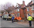
Pruning Trees in The Avenue
These workers from South Somerset District Council are pruning the plane trees and horse chestnut tree that line the road. They are pruned every three or four years to stop them interfering with the houses and overhead cables. Two men were working up in the trees with chainsaws while another two fed the cut branches into the shredder.
Image: © Nigel Mykura
Taken: 11 Feb 2013
0.00 miles
2
Victorian Terraced Houses, Yeovil
In The Avenue, very close to the centre of town, many of these houses have been converted to Houses in Multi Occupation (HMO's) hence the large number of bins outside some houses
Image: © Nigel Mykura
Taken: 16 Jan 2008
0.01 miles
3
Urban Badger Den
This Badger den is in an old disused snicket or pathway that runs behind some Victorian houses. There is the back of a wooden shed on the left with a small brick wall next to it. The badger has removed some of the bricks and made a sizeable hole under the shed. The size of the hole can be judged from the old chair next to it. Most of the pathway is covered with old leaves and detritus but the pathway into the hole was completely clean except for a few badger hairs.(4cm long, one end brown, the other end white). I hesitate to call this a sett because there did not appear to be any other entrances and there was no extensive digging nearby. The well trodden badger paths into the various adjacent gardens could be clearly seen.
Another view of the snicket can be seen here:-
Image
Image: © Nigel Mykura
Taken: 13 Oct 2011
0.02 miles
4
Former Goldcroft Post Office
This is what was
Image just after closure and conversion into two flats.
Image: © Steve Barnes
Taken: 19 Jul 2009
0.04 miles
5
Exclusive Brethren Church Yeovil, Somerset
The brethren exclude themselves completely from people who are not in their church. Among the things they don't do: watch TV, use computers, listen to radio, read newspapers or fiction, own pets, vote, go to university, wear ties, join any group or organisation that includes non-brethren. Sounds like fun, fun, fun! I think this church originally belonged to another denomination and was converted by having all its windows blocked up (to exclude the outside world).
Image: © Nigel Mykura
Taken: 1 Feb 2008
0.05 miles
6
Crofton Park and the rear of the hospital
This shows one limb of Crofton park looking towards the back of the hospital.
Image: © Steve Barnes
Taken: 19 Jul 2009
0.05 miles
7
Snicket, Yeovil
This snicket is just off Crofton Park in Yeovil running between the gardens at the back of two rows of terraced houses. Viewed from where the snicket opens up onto the road it can be seen that the snicket is completely blocked by a shed that has been built across it. The snicket beyond the shed has almost disappeared after having been annexed by the gardens gridlock it.
Image: © Nigel Mykura
Taken: 29 Jan 2009
0.06 miles
8
Unseen Saint
This is on the back of the church and is not easy to see
Image: © Steve Barnes
Taken: 19 Jul 2009
0.06 miles
9
Back Gardens, Yeovil
The red brick wall separates two gardens behind rows of Victorian terraces in Yeovil. Although difficult to see there is a snicket that runs along the wall on the left hand side. The gardens on the left have "reclaimed" the snicket. Until last year there were gates in every garden to allow access along the snicket. Now many gates have been removed and sheds placed over the line of the snicket. This reclamation starts at the end of the snicket furthest from the road and slowly works its way along. Approximately half of the length of the snicket has been reclaimed.
Image: © Nigel Mykura
Taken: 29 Jan 2009
0.07 miles
10
Without the sign you might think this is a through road
Actually it is for pedestrians and cyclists.
Image: © Steve Barnes
Taken: 19 Jul 2009
0.07 miles


