IMAGES TAKEN NEAR TO
The Avenue, YEOVIL, BA21 4BJ
Introduction
This page details the photographs taken nearby to The Avenue, BA21 4BJ by members of the Geograph project.
The Geograph project started in 2005 with the aim of publishing, organising and preserving representative images for every square kilometre of Great Britain, Ireland and the Isle of Man.

There are currently over 7.5m images from over14,400 individuals and you can help contribute to the project by visiting https://www.geograph.org.uk
Image Map
Images are licensed for reuse under creativecommons.org/licenses/by-sa/2.0
Notes
- Clicking on the map will re-center to the selected point.
- The higher the marker number, the further away the image location is from the centre of the postcode.
Image Listing (164 Images Found)
Images are licensed for reuse under creativecommons.org/licenses/by-sa/2.0
Image
Details
Distance
1
Crofton Park and the rear of the hospital
This shows one limb of Crofton park looking towards the back of the hospital.
Image: © Steve Barnes
Taken: 19 Jul 2009
0.01 miles
4
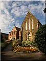
Church of the Holy Ghost , Yeovil
The Roman Catholic Church of The Holy Ghost is at the junction of Higher Kingston and The Avenue, and dates from 1894-9 http://www.imagesofengland.org.uk/details/default.aspx?id=474227 . On the left is the Presbytery, 1899 http://www.imagesofengland.org.uk/Details/Default.aspx?id=474228&mode=adv . Both were designed by Canon A.J.C. Scoles, architect and the parish priest.
Image: © Derek Harper
Taken: 23 Oct 2009
0.03 miles
5
Back Gardens, Yeovil
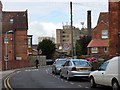
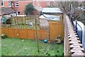
The red brick wall separates two gardens behind rows of Victorian terraces in Yeovil. Although difficult to see there is a snicket that runs along the wall on the left hand side. The gardens on the left have "reclaimed" the snicket. Until last year there were gates in every garden to allow access along the snicket. Now many gates have been removed and sheds placed over the line of the snicket. This reclamation starts at the end of the snicket furthest from the road and slowly works its way along. Approximately half of the length of the snicket has been reclaimed.
Image: © Nigel Mykura
Taken: 29 Jan 2009
0.03 miles
6
Snicket, Yeovil
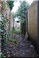
This snicket is just off Crofton Park in Yeovil running between the gardens at the back of two rows of terraced houses. Viewed from where the snicket opens up onto the road it can be seen that the snicket is completely blocked by a shed that has been built across it. The snicket beyond the shed has almost disappeared after having been annexed by the gardens gridlock it.
Image: © Nigel Mykura
Taken: 29 Jan 2009
0.03 miles
7
Unseen Saint
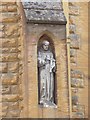
This is on the back of the church and is not easy to see
Image: © Steve Barnes
Taken: 19 Jul 2009
0.03 miles
9
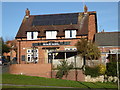
St Gilda's Catholic Primary School, Yeovil
Image: © Chris Allen
Taken: 28 Dec 2017
0.05 miles
10
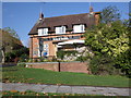
Former Goldcroft Post Office
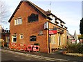
This is what was Image just after closure and conversion into two flats.
Image: © Steve Barnes
Taken: 19 Jul 2009
0.05 miles