IMAGES TAKEN NEAR TO
Combe Street Lane, YEOVIL, BA21 3PF
Introduction
This page details the photographs taken nearby to Combe Street Lane, BA21 3PF by members of the Geograph project.
The Geograph project started in 2005 with the aim of publishing, organising and preserving representative images for every square kilometre of Great Britain, Ireland and the Isle of Man.

There are currently over 7.5m images from over14,400 individuals and you can help contribute to the project by visiting https://www.geograph.org.uk
Image Map (Loading...)


Getting Data...Please wait
Leaflet Map data © OpenStreetMap
Images are licensed for reuse under creativecommons.org/licenses/by-sa/2.0
Notes
- Clicking on the map will re-center to the selected point.
- The higher the marker number, the further away the image location is from the centre of the postcode.
Image Listing (5 Images Found)
Images are licensed for reuse under creativecommons.org/licenses/by-sa/2.0
Image
Details
Distance
1
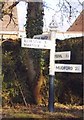
Old Direction Sign - Signpost by Combe Street Lane, Yeovil parish
Pyramid finial - 4 arms; Somerset pointing fingers by the UC road, in parish of Yeovil (South Somerset District), junction with Marsh Lane.
Surveyed
Milestone Society National ID: SO_ST5417
Image: © Milestone Society
Taken: Unknown
0.05 miles
3

Mudford Road Sports Ground
This sports ground hit major controversy when the local council announced that it wished to change it into a major sports complex.
Image: © Steve Barnes
Taken: 22 Aug 2009
0.17 miles
4

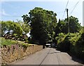
Waste land, Coombe Street lane, Yeovil
This land on the north side of the lane on the edge of Yeovil was once occupied by a now demolished building. It may soon be used as a building site if the northwards expansion of Yeovil continues.
Image: © Nigel Mykura
Taken: 11 Feb 2009
0.20 miles
5
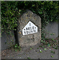
Old Milestone by the A37, Ilchester Road, Yeovil
Metal plate (replica) attached to stone post by the A37, in parish of Yeovil (South Somerset District), Ilchester Road, by No.134, opposite Picketty Witch PH, in pavement in front of slab retaining wall, on East side of road. Yeovil gabled iron plate erected by the Yeovil turnpike trust in the 20th century.
Inscription reads:-
1
MILE
YEOVIL
Somerset HER.
HER number: 14147 https://www.somersetheritage.org.uk/record/14147
Milestone Society National ID: SO_YVIC01
Image: © Alan Rosevear
Taken: 12 Apr 2011
0.25 miles