IMAGES TAKEN NEAR TO
Stoneage Lane, BATH, BA2 0DS
Introduction
This page details the photographs taken nearby to Stoneage Lane, BA2 0DS by members of the Geograph project.
The Geograph project started in 2005 with the aim of publishing, organising and preserving representative images for every square kilometre of Great Britain, Ireland and the Isle of Man.

There are currently over 7.5m images from over14,400 individuals and you can help contribute to the project by visiting https://www.geograph.org.uk
Image Map
Images are licensed for reuse under creativecommons.org/licenses/by-sa/2.0
Notes
- Clicking on the map will re-center to the selected point.
- The higher the marker number, the further away the image location is from the centre of the postcode.
Image Listing (7 Images Found)
Images are licensed for reuse under creativecommons.org/licenses/by-sa/2.0
Image
Details
Distance
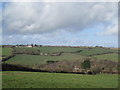
1
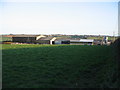
Lower Tunley Farm
A view looking to the southeast from the kissing gate on the public footpath off Stoneage Lane, towards the buildings of Lower Tunley Farm. Peasedown St. John can be seen on the horizon.
Image: © Phil Williams
Taken: 13 Mar 2007
0.03 miles
2
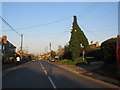
Tunley
A view looking northeast along the B3115 at the junction with Stoneage Lane at Tunley.
Image: © Phil Williams
Taken: 13 Mar 2007
0.17 miles
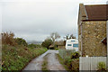
3
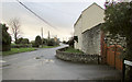
B3315 leaving Tunley
On a grey wet December afternoon. This is at the junction with Blind lane (right) followed by bridleway BA 10/4. On the right is Colliery House, emphasising the importance of coal-mining in this area until 1973.
Image: © Derek Harper
Taken: 6 Dec 2019
0.19 miles
4
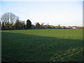
Tunley
A view looking to the northeast from the kissing gate on the public footpath on Stoneage Lane, towards the rear of properties at Tunley, a linear settlement along the B3115.
Image: © Phil Williams
Taken: 13 Mar 2007
0.21 miles
5
View to Tunley
View to Tunley from footpath at Carlingcott
Image: © Michael Claydon
Taken: 13 Feb 2014
0.22 miles

7
Blind Lane, Tunley
Carrying bridleway BA 10/4 along the edge of the village.
Image: © Derek Harper
Taken: 6 Dec 2019
0.23 miles