IMAGES TAKEN NEAR TO
Park Gardens, YEOVIL, BA20 1DW
Introduction
This page details the photographs taken nearby to Park Gardens, BA20 1DW by members of the Geograph project.
The Geograph project started in 2005 with the aim of publishing, organising and preserving representative images for every square kilometre of Great Britain, Ireland and the Isle of Man.

There are currently over 7.5m images from over14,400 individuals and you can help contribute to the project by visiting https://www.geograph.org.uk
Image Map
Images are licensed for reuse under creativecommons.org/licenses/by-sa/2.0
Notes
- Clicking on the map will re-center to the selected point.
- The higher the marker number, the further away the image location is from the centre of the postcode.
Image Listing (200 Images Found)
Images are licensed for reuse under creativecommons.org/licenses/by-sa/2.0
Image
Details
Distance
1
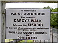
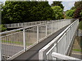
Not Mr Darcy?
The footbridge over the Queensway in Yeovil obviously has a richer history than meets the eye. The local authorities clearly have marked it out as having some importance outside of being a potential accident site. See Image] for a look along it or Image] for a view from it.
Image: © Neil Owen
Taken: 5 Jun 2013
0.04 miles
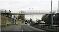
4
Park Bridge over Queensway
Also known as Darcy's Walk, as given in the sign - see Image
Image: © Neil Owen
Taken: 5 Jun 2013
0.04 miles
5
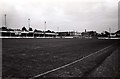
The Huish in Yeovil
The Huish was the home of Yeovil Town from August 1928 until May 1990.
Image: © Steve Daniels
Taken: 6 Aug 1983
0.06 miles
6
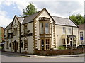
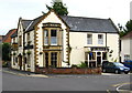
The Armoury
Now a popular pub inviting punters in with sports broadcasts, this originally was an armoury. It was the arms repository of the 16th (Yeovil) Rifle Volunteer Corps. In 1859 the Corps had a Captain, Lieutenant, Ensign and about sixty other ranks. From 1870 it was occupied by many officers who used it as their quarters. Legend has it that powder and ammunition was stored in the cellar.
Image: © Neil Owen
Taken: 5 Jun 2013
0.06 miles
7
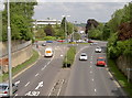
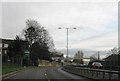
Where Queensway meets Kingston
Or the A30 meets the A37, if you prefer. Yeovil's primary route through town, with Reckleford in the far distance. See Image] for the bridge and Image] for the sign.
Image: © Neil Owen
Taken: 5 Jun 2013
0.06 miles
8
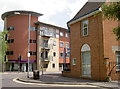
Junction of The Park and Clarence Street
The nearer building is evidently a bit older, having a benchmark on it. See http://www.bench-marks.org.uk/bm37120 for the log in the Benchmark Database.
Image: © Neil Owen
Taken: 5 Jun 2013
0.06 miles
10
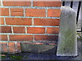
Benchmark on DWP's Telford House, The Park
Ordnance Survey cut mark benchmark described on the Bench Mark Database at http://www.bench-marks.org.uk/bm37120
Image: © Roger Templeman
Taken: 24 Feb 2011
0.07 miles