IMAGES TAKEN NEAR TO
Langridge Lane, BATH, BA1 9BX
Introduction
This page details the photographs taken nearby to Langridge Lane, BA1 9BX by members of the Geograph project.
The Geograph project started in 2005 with the aim of publishing, organising and preserving representative images for every square kilometre of Great Britain, Ireland and the Isle of Man.

There are currently over 7.5m images from over14,400 individuals and you can help contribute to the project by visiting https://www.geograph.org.uk
Image Map
Images are licensed for reuse under creativecommons.org/licenses/by-sa/2.0
Notes
- Clicking on the map will re-center to the selected point.
- The higher the marker number, the further away the image location is from the centre of the postcode.
Image Listing (14 Images Found)
Images are licensed for reuse under creativecommons.org/licenses/by-sa/2.0
Image
Details
Distance
2
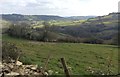
View from Langridge
Langridge straggles in two parts along the ridge which gives it its name. This view is enjoyed by Langridge House, just behind the photographer.
Image: © HelenK
Taken: 16 Mar 2016
0.07 miles
3
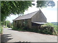
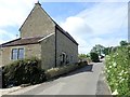
2008 : Cottage at Upper Langridge
Langridge Lane is between the field wall and the cottage.
Go with a friend and two cars, if you want a downhill walk leave one car at Swainswick, bring the other up to Lansdown and walk along Langridge Lane down to Swainswick, or vice versa if you like walking up hill. Either way you can finish up at Lansdown for refreshments.
OS Explorer no. 155 would be useful.
Image: © Maurice Pullin
Taken: 4 Mar 2008
0.09 miles
4
Rolling countryside north of Bath
Looking towards Swainswick valley
Image: © Eirian Evans
Taken: 30 May 2019
0.09 miles
5
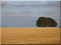
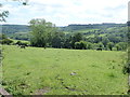
Stubble and copse.
There is actually a road between the field and the copse. The wall to the left of the photo indicates where it runs.
Image: © Sharon Loxton
Taken: 7 Sep 2007
0.10 miles
6
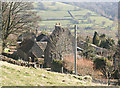
2008 : Upper Langridge, north of Lansdown
We are looking at Upper Langridge from the driveway approaching Upper Langridge Farm.
The fields beyond are on the other side of the valley, the A46 to Cheltenham is above the woods on the right and Charmy Down is above that.
Image: © Maurice Pullin
Taken: 4 Mar 2008
0.10 miles
7
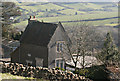
Langridge House
Nestling into the hillside high above the Swainswick Valley, this house is now holiday accommodation.
Image: © Eirian Evans
Taken: 30 May 2019
0.10 miles
9

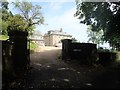
2008 : Farm entrance at Upper Langridge
Looking to the right from here there are some fine views down the valley.
Image: © Maurice Pullin
Taken: 4 Mar 2008
0.11 miles
10
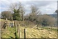
Path beside the lane
This stretch of path runs alongside the lane. It is not very clear why a separate path is needed here as the lane is very quiet; perhaps the path has been slightly diverted from a more southerly course. The gate is new, installed by local volunteers.
Image: © HelenK
Taken: 16 Mar 2016
0.16 miles