IMAGES TAKEN NEAR TO
/Lansdown Tower, BATH, BA1 9BH
Introduction
This page details the photographs taken nearby to /Lansdown Tower, BA1 9BH by members of the Geograph project.
The Geograph project started in 2005 with the aim of publishing, organising and preserving representative images for every square kilometre of Great Britain, Ireland and the Isle of Man.

There are currently over 7.5m images from over14,400 individuals and you can help contribute to the project by visiting https://www.geograph.org.uk
Image Map
Images are licensed for reuse under creativecommons.org/licenses/by-sa/2.0
Notes
- Clicking on the map will re-center to the selected point.
- The higher the marker number, the further away the image location is from the centre of the postcode.
Image Listing (65 Images Found)
Images are licensed for reuse under creativecommons.org/licenses/by-sa/2.0
Image
Details
Distance
1
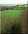
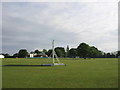
Brownsword Cricket Ground, Lansdown
Like Image], a view from the belvedere on Beckford's Tower Image I said the weather was poor, but now I've fiddled around with contrast etc, I can see there is sunshine over on Kelston Round Hill, which goes to show how bad visibility is through the windows. In the foreground is Brownsword Cricket Ground, with a rugby ground beyond.
Image: © Derek Harper
Taken: 7 Dec 2019
0.07 miles
2
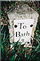
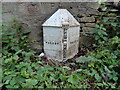
Old Milestone, Lansdown Rd
Metal plate attached to stone post by the UC road, in parish of CHARLCOMBE (BATH AND NORTH EAST SOMERSET District), Landsdown Road, Bath, opp. Beckford's Tower, on grass verge, outside gate to school grounds, on North side of road. Bath incised iron plate Erected by the Bath turnpike trust in the 18th century. Alternative view see https://www.geograph.org.uk/photo/6072403
Inscription reads: To / Bath / 2
Milestone Society National ID: SO_BAWK02
Image: © Janet Dowding
Taken: 31 Jan 2021
0.08 miles
3
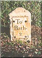
Old Milestone by Lansdown Road, Bath
Metal plate attached to stone post by the UC road, in parish of CHARLCOMBE (BATH AND NORTH EAST SOMERSET District), Lansdown Road, Bath, opposite Beckford's Tower, on grass verge, outside gate to school grounds, on North side of road. Bath incised iron plate, erected by the Bath turnpike trust in the 18th century.
Inscription reads:-
To
Bath
2
Milestone Society National ID: SO_BAWK02.
Image: © JR Dowding
Taken: 31 Mar 2008
0.08 miles
5

Spiral staircase within Beckford's Tower
Image: © Colin Park
Taken: 20 Apr 1987
0.09 miles
7
2008 : Old Silurians RFC, Lansdown
Behind the information board we see a good looking ground with well kept turf and part of a view over north Somerset.
Looked for Old Silurians on the internet but all I found was an old episode of Dr.Who.
Image: © Maurice Pullin
Taken: 13 Jun 2008
0.09 miles
8
Beckford's tower from Kingswood upper playing field
Matches on these fields are among many things which can be seen from the top of the tower.
From the Tower website http://beckfordstower.org.uk/history/ "Beckford’s Tower was designed by Henry Edmund Goodridge in 1825 and completed in 1827 for William Beckford (1760-1844), one of the nation’s most accomplished and interesting characters. The 120-foot neo-classical Tower, which enjoys uninterrupted views of the countryside, was constructed as a study retreat and to house Beckford’s precious collection of art and rare books.
The Tower is now home to a museum collection displaying furniture originally made for the Tower, alongside paintings, prints and objects illustrating William Beckford’s life as a writer, collector and patron of the arts.
Visitors can follow in Beckford’s footsteps and climb the spiral staircase to the beautifully restored Belvedere and experience the spectacular panoramic view of Bath.
The Tower is an extraordinary building that stands today as the only surviving example of William Beckford’s great architectural achievements."
The Tower was for a time in the care of St Stephen's Church Image and a particularly philistine vicar in the 1960s wanted to have it pulled down, but it was saved thanks to the good offices of the Bath Preservation Trust.
Image: © HelenK
Taken: 18 May 2011
0.10 miles
9
Old Boundary Markers on Lansdown Road, Charlcombe
Two boundary markers on the southwest side of Lansdown Road against the wall of the grounds of Beckford's Tower. Originally on the boundary of Walcot and Weston parishes. From 1900 the boundary of Bath and Weston parishes. From 1953 Bath and Charlcombe parishes. Now entirely in an unparished area. See also https://www.geograph.org.uk/photo/6050031.
In front is a Turnpike Parish Boundary Marker. It is marked WALCOT on the left face, WESTON on the right face, separated by (BATH) TURNPIKE TRUST vertically with the date 1827 above.
Milestone Society National ID: SO_BAWK02pb
Directly above is a Parish Boundary Marker inscribed W T P for Weston Parish.
Milestone Society National ID: SO_BAWK04pb
Image: © Roadside Relics
Taken: 5 Jun 2024
0.11 miles
10

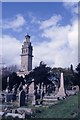
Beckford's Tower
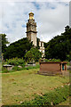
Beckford's Tower with Beckford's tomb in the foreground.
Image: © Ray Beer
Taken: 25 Aug 2006
0.11 miles