IMAGES TAKEN NEAR TO
Northend, BATH, BA1 8ES
Introduction
This page details the photographs taken nearby to Northend, BA1 8ES by members of the Geograph project.
The Geograph project started in 2005 with the aim of publishing, organising and preserving representative images for every square kilometre of Great Britain, Ireland and the Isle of Man.

There are currently over 7.5m images from over14,400 individuals and you can help contribute to the project by visiting https://www.geograph.org.uk
Image Map
Images are licensed for reuse under creativecommons.org/licenses/by-sa/2.0
Notes
- Clicking on the map will re-center to the selected point.
- The higher the marker number, the further away the image location is from the centre of the postcode.
Image Listing (11 Images Found)
Images are licensed for reuse under creativecommons.org/licenses/by-sa/2.0
Image
Details
Distance
1
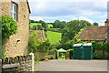
2008 : Radford Farm, St.Catherine's Valley
An ex farm between Fairhaven Cottages and Oldhouse Farm.
Image: © Maurice Pullin
Taken: 4 Jul 2008
0.03 miles
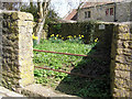
2
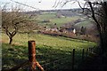
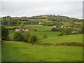
Northend
View over an old orchard towards the lower road from the footpath below Ramscombe Lane.
Image: © Derek Hawkins
Taken: 4 Feb 2007
0.05 miles
3
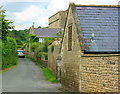
2008 : St. Catherine's Valley
The lane through St.Catherine's Valley as it passes Oldhouse Farm.
Image: © Maurice Pullin
Taken: 4 Jul 2008
0.07 miles
4
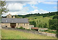
2008 : Oldhouse Farm, St.Catherine's Valley
Fields to the right of the farm are on the eastern slopes of St.Catherine's Valley, well worth a visit but beware of steep hills and sharp bends on this narrow lane.
Image: © Maurice Pullin
Taken: 4 Jul 2008
0.07 miles
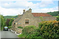
5
Pound, North End, Batheaston
In 1719 it cost 2/6d for a stray sheep to be released from here, horse or beast 5/- for every days trespass. Good idea. More information at http://users.bathspa.ac.uk/batheaston/be050.asp
Image: © Rick Crowley
Taken: 9 Apr 2010
0.10 miles
6
2008 : Fairhaven Cottages, St. Catherines Valley
The road through the valley as it passes Fairhaven Cottages.
Hope there is enough here and in other photos is this square to tempt you to visit St.Catherine's Valley, it gets better as it goes up and this is near the bottom. The road ends near Nimlet on the A46.
Image: © Maurice Pullin
Taken: 4 Jul 2008
0.12 miles
7
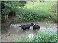
Cattle having a dip in St Catherine's Brook
Image: © Basher Eyre
Taken: 15 Sep 2013
0.16 miles
8
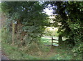
Path to Upper Northend House
The path's course appears to have been altered over recent years but still largely drops down the hill.
Image: © Neil Owen
Taken: 18 Oct 2016
0.18 miles
9

Northend
A view across the St Catherines Valley overlooking the lower road from a footpath below Ranscombe Lane.
Image: © Derek Hawkins
Taken: 4 Feb 2007
0.21 miles
10
Upper Northend Farm, St Catherine's Valley
Image: © Colin Park
Taken: 21 Oct 2009
0.24 miles