IMAGES TAKEN NEAR TO
Dovers Park, BATH, BA1 7UE
Introduction
This page details the photographs taken nearby to Dovers Park, BA1 7UE by members of the Geograph project.
The Geograph project started in 2005 with the aim of publishing, organising and preserving representative images for every square kilometre of Great Britain, Ireland and the Isle of Man.

There are currently over 7.5m images from over14,400 individuals and you can help contribute to the project by visiting https://www.geograph.org.uk
Image Map
Images are licensed for reuse under creativecommons.org/licenses/by-sa/2.0
Notes
- Clicking on the map will re-center to the selected point.
- The higher the marker number, the further away the image location is from the centre of the postcode.
Image Listing (24 Images Found)
Images are licensed for reuse under creativecommons.org/licenses/by-sa/2.0
Image
Details
Distance
1

Bathford School
The Primary school moved from its old location on Church Street to this location from 1965 to 1970, with the old school building sold off in 1972.
Image: © Derek Hawkins
Taken: 2 Mar 2002
0.12 miles
2

2007 : View from Bathford Hill
Taken from a clear patch on Bathford Hill. On the distant skyline in the centre is a row of trees planted along the top of Freezing Hill. ST7271 Immediately beneath them, and just below the skyline is the top of Little Solsbury Hill. ST7667
Moving left we can see the northern end of Lansdown, where the battle of Lansdown was fought in 1643. Lansdown Hill continues to the edge of the picture.
To the right of Freezing Hill part of Charmy Down appears, there is a disused airfield at the top which is still put to good use by model aeroplane and glider enthusiasts.
About half way down we have part of Batheaston, the railway line out of Bath and the Batheaston bypass are almost hidden by the trees at the bottom.
Image: © Maurice Pullin
Taken: 4 Sep 2007
0.13 miles
3

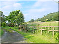
Dovers Lane
Just off Bathford Hill with its shop and houses is this very rural lane.
Image: © HelenK
Taken: 30 Jul 2015
0.17 miles
4

The Post Office at Bathford
The Post Office at Bathford is in a prominent position as you travel up the hill towards Kingsdown.
Image: © Phil Williams
Taken: 13 Oct 2005
0.17 miles
5
Bathford, 1987
View westward down High Street.
Image: © Ben Brooksbank
Taken: 6 May 1987
0.18 miles
6
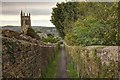
Bathford Hill
Bathford Hill is the wooded slope on the right. The track is the driveway to Warleigh Lodge on the Bradford Rd the A363.
Image: © Nigel Mykura
Taken: 8 Jul 2012
0.19 miles
8
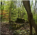
'Watch Point'
Image of what I saw from a point on a rural public footpath, in a woodland copse.
Trees, vegetation, light, shade and colours, on the ground, trees and beyond.
A 'frame' is suggested within the image by the vertical trees and angled branch.
What is within the 'frame' what is outside, foreground, middle and background.
Good depth of field, exposure.
Image: © D M Wilmot
Taken: 21 Apr 2022
0.20 miles
9

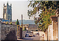
Bathford High Street
This is a view looking down Bathford High Street with the allotments on the right.
Image: © Derek Hawkins
Taken: 2 Mar 2002
0.21 miles
10

Bathford High Street
View up Bathford High Street with the chapel and the Clothes Horse that was originally The Upper Stores.
Image: © Derek Hawkins
Taken: 2 Mar 2002
0.22 miles