
IMAGES TAKEN NEAR TO
Bailbrook Lane, BATH, BA1 7AJ
Introduction
This page details the photographs taken nearby to Bailbrook Lane, BA1 7AJ by members of the Geograph project.
The Geograph project started in 2005 with the aim of publishing, organising and preserving representative images for every square kilometre of Great Britain, Ireland and the Isle of Man.

There are currently over 7.5m images from over14,400 individuals and you can help contribute to the project by visiting https://www.geograph.org.uk
Image Map
Images are licensed for reuse under creativecommons.org/licenses/by-sa/2.0
Notes
- Clicking on the map will re-center to the selected point.
- The higher the marker number, the further away the image location is from the centre of the postcode.
Image Listing (30 Images Found)
Images are licensed for reuse under creativecommons.org/licenses/by-sa/2.0
Image
Details
Distance
1
Bath : Batheaston Swainswick Bypass
A road leading into Bath and out to the rest of North Somerset
Image: © Lewis Clarke
Taken: 22 Oct 2008
0.03 miles
2
Swainswick : A46
Looking along the A46.
Image: © Lewis Clarke
Taken: 18 Oct 2022
0.04 miles
3
A46 underpass at Lower Swainswick
Approaching the junction with the A4
Image: © David Smith
Taken: 26 Nov 2016
0.05 miles
4

A46 tunnel, Lower Swainswick
Cut and cover construction, about 70 m long.
Image: © Robin Webster
Taken: 13 Nov 2022
0.06 miles
5
Overbridge over A46 near Lower Swainswick
First overbridge after the junction with the A4
Image: © John Firth
Taken: 4 Sep 2017
0.07 miles
6
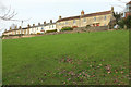
Terrace, Bailbrook Lane
The terrace of seven is listed https://historicengland.org.uk/listing/the-list/list-entry/1394163 and part of it is also shown at Image A small part of Image] appears on the right.
Image: © Derek Harper
Taken: 8 Dec 2019
0.10 miles
7
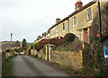
Terrace, Bailbrook Lane
Looking left from beside Image The terrace of seven is listed https://historicengland.org.uk/listing/the-list/list-entry/1394163 .
Image: © Derek Harper
Taken: 8 Dec 2019
0.10 miles
8
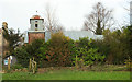
Former Bailbrook Mission Church
"Bailbrook Mission Church was opened on 4 July 1892 for workers in the local Robertson jam orchards" https://historicengland.org.uk/services-skills/education/educational-images/bailbrook-mission-church-bailbrook-lane-bath-4821 . "Timber-frame clad in corrugated iron, with corrugated iron roof ... An exceptionally elaborate example of a "tin tabernacle", an industrially produced (and generally temporary) form of church incorporating early systems of pre-fabricated construction. This particular example was the most expensive (and ecclesiastically correct) design, taken from a catalogue of 1889 by William Cooper, Old Kent Road, London. Formerly in a poor state of repair" https://historicengland.org.uk/listing/the-list/list-entry/1394166 .
On the left is the end of the terrace described at https://historicengland.org.uk/listing/the-list/list-entry/1394163 .
Image: © Derek Harper
Taken: 8 Dec 2019
0.12 miles

10

A46 approaching A4 junction
The road continues to descend to the roundabout at the junction.
Image: © J.Hannan-Briggs
Taken: 30 Jul 2014
0.13 miles