IMAGES TAKEN NEAR TO
Fielding Road, STREET, BA16 9PG
Introduction
This page details the photographs taken nearby to Fielding Road, BA16 9PG by members of the Geograph project.
The Geograph project started in 2005 with the aim of publishing, organising and preserving representative images for every square kilometre of Great Britain, Ireland and the Isle of Man.

There are currently over 7.5m images from over14,400 individuals and you can help contribute to the project by visiting https://www.geograph.org.uk
Image Map
Images are licensed for reuse under creativecommons.org/licenses/by-sa/2.0
Notes
- Clicking on the map will re-center to the selected point.
- The higher the marker number, the further away the image location is from the centre of the postcode.
Image Listing (35 Images Found)
Images are licensed for reuse under creativecommons.org/licenses/by-sa/2.0
Image
Details
Distance


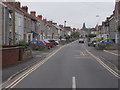
6
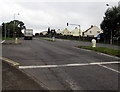
Westway junction in Street, Somerset
The main road is the A39 Westway. Traffic lights control this junction
with Farm Road on the left, the way to Clarks Village and the town centre.
Image: © Jaggery
Taken: 27 Sep 2016
0.17 miles
7
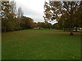
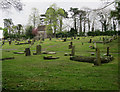
A little bit of green
A small area of parkland next to the cemetery.
Image: © Anthony Vosper
Taken: 28 Oct 2017
0.17 miles

9
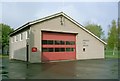
Street Fire Station
Street Fire Station, Cranhill Road, Street, Somerset.
Image: © Kevin Hale
Taken: 25 Apr 1993
0.18 miles
10
Cranhill Road - Southleaze Orchard
Image: © Betty Longbottom
Taken: 8 Jun 2016
0.18 miles