IMAGES TAKEN NEAR TO
Cranhill Road, STREET, BA16 0BY
Introduction
This page details the photographs taken nearby to Cranhill Road, BA16 0BY by members of the Geograph project.
The Geograph project started in 2005 with the aim of publishing, organising and preserving representative images for every square kilometre of Great Britain, Ireland and the Isle of Man.

There are currently over 7.5m images from over14,400 individuals and you can help contribute to the project by visiting https://www.geograph.org.uk
Image Map
Images are licensed for reuse under creativecommons.org/licenses/by-sa/2.0
Notes
- Clicking on the map will re-center to the selected point.
- The higher the marker number, the further away the image location is from the centre of the postcode.
Image Listing (215 Images Found)
Images are licensed for reuse under creativecommons.org/licenses/by-sa/2.0
Image
Details
Distance
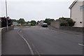
1
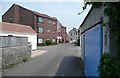
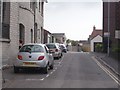
Street back street
Not all the buildings in Street are the attractive Mendip stone. These came as quite a shock for daring to be different.
Image: © Graham Horn
Taken: 11 May 2008
0.04 miles
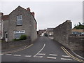
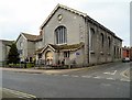
4
Street United Reformed Church
At one end of the High Street, this is an imposing building even though it is in the same colour stone as much of the rest of the village.
Image: © Graham Horn
Taken: 11 May 2008
0.05 miles
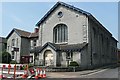
7
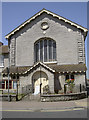
United Reformed Church
The imposing grey stonework of the church in the High Street. See Image] for the round detail.
Image: © Neil Owen
Taken: 9 Jul 2013
0.07 miles
8
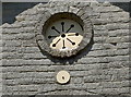
Round perch
The circular feature seems home to someone. See Image] for the wider view.
Image: © Neil Owen
Taken: 9 Jul 2013
0.07 miles
9
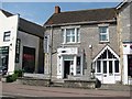
Street Angling Centre
Shop on the High Street, Street.
Image: © Richard Webb
Taken: 21 Apr 2011
0.07 miles
10
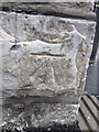
Ordnance Survey Cut Mark
This OS cut mark can be found on the corner of Living Homes. It marks a point 17.4492m above mean sea level.
Image: © Adrian Dust
Taken: 21 Nov 2014
0.08 miles