IMAGES TAKEN NEAR TO
Farm Road, STREET, BA16 0BS
Introduction
This page details the photographs taken nearby to Farm Road, BA16 0BS by members of the Geograph project.
The Geograph project started in 2005 with the aim of publishing, organising and preserving representative images for every square kilometre of Great Britain, Ireland and the Isle of Man.

There are currently over 7.5m images from over14,400 individuals and you can help contribute to the project by visiting https://www.geograph.org.uk
Image Map
Images are licensed for reuse under creativecommons.org/licenses/by-sa/2.0
Notes
- Clicking on the map will re-center to the selected point.
- The higher the marker number, the further away the image location is from the centre of the postcode.
Image Listing (223 Images Found)
Images are licensed for reuse under creativecommons.org/licenses/by-sa/2.0
Image
Details
Distance
1
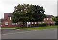
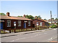
Northleaze House, Street, Somerset
Retirement housing viewed across Farm Road.
Image: © Jaggery
Taken: 27 Sep 2016
0.01 miles
2
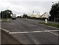
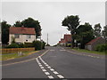
Westway junction in Street, Somerset
The main road is the A39 Westway. Traffic lights control this junction
with Farm Road on the left, the way to Clarks Village and the town centre.
Image: © Jaggery
Taken: 27 Sep 2016
0.02 miles
3

Street : Farm Road
Farm Road in Street from the A39 West Way.
Image: © Lewis Clarke
Taken: 15 Jun 2012
0.02 miles
4
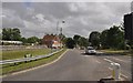
Street : Farm Road
Farm Road in Street from West Way A39.
Image: © Lewis Clarke
Taken: 15 Jun 2012
0.02 miles
5
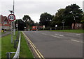
Start of the 30 zone, Farm Road, Street, Somerset
The 40mph speed limit on the A39 Westway behind the camera drops to 30mph on Farm Road.
Image: © Jaggery
Taken: 27 Sep 2016
0.03 miles
6

Half and half house in Street, Somerset
The house on the corner of Farm Road and Barn Close has a stone ground floor with a brick first floor.
Image: © Jaggery
Taken: 27 Sep 2016
0.04 miles
7

Barn Close, Street, Somerset
From the corner of Farm Road.
Image: © Jaggery
Taken: 27 Sep 2016
0.05 miles
8

Start of the 20 zone, Farm Road, Street, Somerset
The 30mph speed limit drops to 20mph.
Image: © Jaggery
Taken: 27 Sep 2016
0.05 miles
9
Such a contrast
Street High Street is noted for its fine grey stone buildings; the Clark's Village leading off it is noted for the many outlet shops that now occupy the former factory estate. However, just across from the northwestern end are these wooden chalet-style houses. They seem to be available to let.
Image: © Neil Owen
Taken: 9 Jul 2013
0.05 miles
10
Farm Road - viewed from Southleaze Orchard
Image: © Betty Longbottom
Taken: 8 Jun 2016
0.06 miles