IMAGES TAKEN NEAR TO
College Road, BATH, BA1 5RU
Introduction
This page details the photographs taken nearby to College Road, BA1 5RU by members of the Geograph project.
The Geograph project started in 2005 with the aim of publishing, organising and preserving representative images for every square kilometre of Great Britain, Ireland and the Isle of Man.

There are currently over 7.5m images from over14,400 individuals and you can help contribute to the project by visiting https://www.geograph.org.uk
Image Map
Images are licensed for reuse under creativecommons.org/licenses/by-sa/2.0
Notes
- Clicking on the map will re-center to the selected point.
- The higher the marker number, the further away the image location is from the centre of the postcode.
Image Listing (50 Images Found)
Images are licensed for reuse under creativecommons.org/licenses/by-sa/2.0
Image
Details
Distance
1
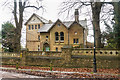
Laggan House
Large Victorian house in College Road now divided into seven flats. It was originally called The Limes, before its name was changed to Laggan (appearing as such in the 1933 6 inch map), before the addition of the word House gave it its current name.
Among its uses have been a boarding house for the Royal School for Daughters of Officers of the Army in nearby Lansdown Road (now part of Royal High School, Bath). In the early part of the Second World War, the school was evacuated to Longleat, and was requisitioned by the Admiralty's Hydrographic Department, and Laggan was used to house HM Nautical Almanac Office as well as the Assistant Hydrographer, the Tides Department and the Superintendent of Sailing Directions and his staff. These were housed here from September 1939 until November 1941 when they moved to Block E of new office developments at Ensleigh, further up Lansdown Road (see Image).
For article on the HMNAO, including its time at Laggan, see http://www.royalobservatorygreenwich.org/articles.php?article=913.
Image: © Ian Capper
Taken: 11 Dec 2015
0.04 miles
2
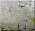
Ordnance Survey Cut Mark
This OS cut mark can be found on the wall at the junction of College Road & Waldegrove Road. It marks a point 145.344m above mean sea level.
Image: © Adrian Dust
Taken: 25 May 2024
0.10 miles
3

Sion Hill Place, Bath
The Royal Crescent and Circus tend to get the attention, but wander off the beaten track and one can find other Georgian treasures such as this magnificent terrace hidden away at the top of Sion Hill. By John Pinch, c1817-20. Treated as a single composition with the usual central emphasis, a three-bay pediment, and terminal emphases, full-height bows. Grade I listed.
The section before the first bow, disrupting the symmetry, belongs to nos. 1-2, Summerhill Place.
Image: © Stephen Richards
Taken: 25 May 2012
0.10 miles
4
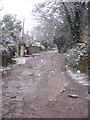
Waldegrave Road, Bath - enter at your own risk
This road is unadopted. Rather than being resurfaced and becoming a short-cut for parents at nearby Kingswood School, it has been allowed to deteriorate into something resembling a war zone. Only the most rugged of vehicles can now pass along it and it can only be a matter of time before the Post Office refuses to deliver to properties here, as it has done elsewhere in similar cases. One solution would be for the Council to take over all the land that is not required for access and sell it with planning permission to a developer, since it's clear that local residents don't need or want a thoroughfare here. As property prices in this area are among the highest in Bath, this might prove quite lucrative.
Image: © HelenK
Taken: 14 Dec 2011
0.10 miles
5

Pine, Sion Road, Bath
A lofty Scots pine, often a striking and handsome tree when it has space to spread out a little.
Image: © Stephen Richards
Taken: 25 May 2012
0.15 miles
6
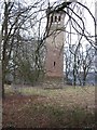
Blaines Tower
Folly tower in the grounds of Kingswood College
Image: © Paul Brooker
Taken: 9 Mar 2010
0.16 miles
7
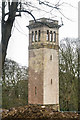
Blaine's Folly
Belvedere tower built in around 1870 by Sir Robert Blaine, later MP for Bath, who had bought Summerhill Park in 1868. It is suggested that he had the tower built as a job creation scheme. Grade II listed - see http://www.historicengland.org.uk/listing/the-list/list-entry/1394944.
Image: © Ian Capper
Taken: 11 Dec 2015
0.16 miles
8

St Winifred's Well Cottage
Grade II listed cottage in Winifred's Lane, dating from the mid to late 18th Century - see http://www.historicengland.org.uk/listing/the-list/list-entry/1395786.
Image: © Ian Capper
Taken: 11 Dec 2015
0.16 miles
9

Ordnance Survey Cut Mark
This OS cut mark can be found on the wall SE side of College Road. It marks a point 151.902m above mean sea level.
Image: © Adrian Dust
Taken: 25 May 2024
0.17 miles
10
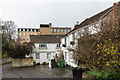
Somerset Lane
Cottages in Somerset Lane, with part of Bath Spa University in the background.
Image: © Ian Capper
Taken: 11 Dec 2015
0.17 miles