IMAGES TAKEN NEAR TO
Lower South Wraxall, BRADFORD-ON-AVON, BA15 2DJ
Introduction
This page details the photographs taken nearby to BA15 2DJ by members of the Geograph project.
The Geograph project started in 2005 with the aim of publishing, organising and preserving representative images for every square kilometre of Great Britain, Ireland and the Isle of Man.

There are currently over 7.5m images from over14,400 individuals and you can help contribute to the project by visiting https://www.geograph.org.uk
Image Map
Images are licensed for reuse under creativecommons.org/licenses/by-sa/2.0
Notes
- Clicking on the map will re-center to the selected point.
- The higher the marker number, the further away the image location is from the centre of the postcode.
Image Listing (9 Images Found)
Images are licensed for reuse under creativecommons.org/licenses/by-sa/2.0
Image
Details
Distance
1
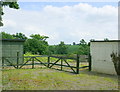
2008 : Disused animal pen near Poor House Cottage
On the minor road heading to Lower Wraxall.
Seems a bit small for horses, pigs would make short work of that fence.
Image: © Maurice Pullin
Taken: 30 May 2008
0.02 miles
2

Junction by Poor House Cottage
Junction by Poor House Cottage with the road straight ahead signposted to Trowbridge
Image: © Shaun Ferguson
Taken: 5 Jan 2018
0.05 miles
3
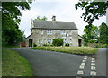
2008 : Poor House Cottage
On the Atworth to Holt road. The road to the left goes to Lower Wraxall.
Image: © Maurice Pullin
Taken: 30 May 2008
0.05 miles
4
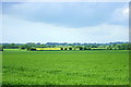
2008 : Farmland between Little Chalfield and Wraxall
Looking north from Poor House the land rises gently towards Stonar School.
Image: © Maurice Pullin
Taken: 30 May 2008
0.11 miles
5
Poorhouse Cottage
A view looking north along the lane to Poorhouse Cottage over a culvert carrying a tributary of the River Avon under the lane. Note the use of old railway carriages as sheds in the paddock at left.
Image: © Phil Williams
Taken: 23 Mar 2006
0.13 miles
6
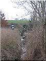
Poorhouse Weir Source
A view looking southwest along a tributary of the River Avon towards the abstraction point at Poorhouse Weir.
Image: © Phil Williams
Taken: 23 Mar 2006
0.13 miles
7
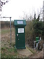
Poorhouse Weir abstraction point
A view looking southwest to the abstraction point at Poorhouse Weir. The solar cell is presumably for the remote monitoring equipment with its associated Yagi aerial (left).
Image: © Phil Williams
Taken: 23 Mar 2006
0.13 miles
8

Friendly equine
A view looking north across a paddock at Poorhouse Weir.
Image: © Phil Williams
Taken: 23 Mar 2006
0.13 miles
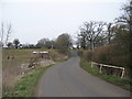
9

Lane heading north east near Poor House Cottage
Image: © Rob Purvis
Taken: 11 Jun 2013
0.14 miles