IMAGES TAKEN NEAR TO
Warbler Close, TROWBRIDGE, BA14 9TY
Introduction
This page details the photographs taken nearby to Warbler Close, BA14 9TY by members of the Geograph project.
The Geograph project started in 2005 with the aim of publishing, organising and preserving representative images for every square kilometre of Great Britain, Ireland and the Isle of Man.

There are currently over 7.5m images from over14,400 individuals and you can help contribute to the project by visiting https://www.geograph.org.uk
Image Map
Images are licensed for reuse under creativecommons.org/licenses/by-sa/2.0
Notes
- Clicking on the map will re-center to the selected point.
- The higher the marker number, the further away the image location is from the centre of the postcode.
Image Listing (10 Images Found)
Images are licensed for reuse under creativecommons.org/licenses/by-sa/2.0
Image
Details
Distance

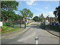
3

2007 : Wingfield Road looking west
Here the road looks more like a quiet urban street, but it is the A366 heading for Norton St. Philip and beyond. You should see it at 8.45am.
Image: © Maurice Pullin
Taken: 6 Nov 2007
0.20 miles
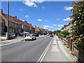
4

Westbourne Road, Trowbridge
Viewed from the Wingfield Road end. A sign with a white arrow on a blue background shows that a one-way traffic system, away from the camera, operates here. Vehicles heavier than 7.5 tonnes are forbidden from entering the road, except for loading.
Image: © Jaggery
Taken: 5 Dec 2011
0.21 miles
6

2007 : Housing near Trowle Bridge, Trowbridge
These houses are at the edge of an estate of modern dwellings stretching about half a mile to the west. Although of better appearance than most they still remind one of Malvina Reynolds' "Little Boxes" as performed by Pete Seeger. http://en.wikipedia.org/wiki/Little_Boxes
People have to live somewhere.
Image: © Maurice Pullin
Taken: 6 Nov 2007
0.22 miles
7

2007 : Westbourne Road
One of the residential streets leading off Wingfield Road. Included to show Trowbridge has its good bits. This could, with justification, be called an avenue.
Image: © Maurice Pullin
Taken: 6 Nov 2007
0.22 miles
8

Terraced houses in Bradford Road, Trowbridge
Image: © David Smith
Taken: 7 Jun 2017
0.23 miles
9
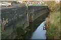
2007 : Trowle Bridge, Trowbridge
The River Biss does not pass through Trowle Bridge which was built to accommodate Lambrok Stream, one of its tributaries. The other side of the bridge is an unpleasant mess.
Effluent from new housing developments during the 1950s and 60s seriously overloaded Trowbridge's sewage system. The resulting stink in this area cannot be imagined; it can only be remembered. The situation is far more salubrious these days.
Image: © Maurice Pullin
Taken: 6 Nov 2007
0.24 miles
10
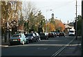
2007 : Wingfield Road, Trowbridge
Situated in one of the more pleasant areas of Trowbridge, St.John's Church is at the town end of Wingfield Road.
Image: © Maurice Pullin
Taken: 6 Nov 2007
0.24 miles