IMAGES TAKEN NEAR TO
Bradford Road, TROWBRIDGE, BA14 9AZ
Introduction
This page details the photographs taken nearby to Bradford Road, BA14 9AZ by members of the Geograph project.
The Geograph project started in 2005 with the aim of publishing, organising and preserving representative images for every square kilometre of Great Britain, Ireland and the Isle of Man.

There are currently over 7.5m images from over14,400 individuals and you can help contribute to the project by visiting https://www.geograph.org.uk
Image Map
Images are licensed for reuse under creativecommons.org/licenses/by-sa/2.0
Notes
- Clicking on the map will re-center to the selected point.
- The higher the marker number, the further away the image location is from the centre of the postcode.
Image Listing (41 Images Found)
Images are licensed for reuse under creativecommons.org/licenses/by-sa/2.0
Image
Details
Distance
1
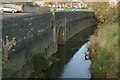
2007 : Trowle Bridge, Trowbridge
The River Biss does not pass through Trowle Bridge which was built to accommodate Lambrok Stream, one of its tributaries. The other side of the bridge is an unpleasant mess.
Effluent from new housing developments during the 1950s and 60s seriously overloaded Trowbridge's sewage system. The resulting stink in this area cannot be imagined; it can only be remembered. The situation is far more salubrious these days.
Image: © Maurice Pullin
Taken: 6 Nov 2007
0.06 miles
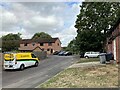
4
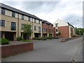
Newly built townhouses, Cockhill, Trowbridge
Image: © David Smith
Taken: 7 Jun 2017
0.11 miles
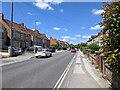
5
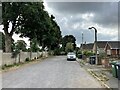
Linden Place in Trowbridge
This road is tucked away in the south east corner of this grid square. Stallard Recreation Field is beyond the wall to the left of picture.
Image: © Jonathan Clitheroe
Taken: 4 Sep 2022
0.13 miles
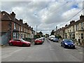
6

Terraced houses in Bradford Road, Trowbridge
Image: © David Smith
Taken: 7 Jun 2017
0.13 miles
7

2007 : Housing near Trowle Bridge, Trowbridge
These houses are at the edge of an estate of modern dwellings stretching about half a mile to the west. Although of better appearance than most they still remind one of Malvina Reynolds' "Little Boxes" as performed by Pete Seeger. http://en.wikipedia.org/wiki/Little_Boxes
People have to live somewhere.
Image: © Maurice Pullin
Taken: 6 Nov 2007
0.14 miles
9
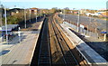
A view NW from Trowbridge railway station footbridge
Viewed from this footbridge. http://www.geograph.org.uk/photo/2739187
The station is on the Wessex line. The next station in this direction for most services is Bradford-on-Avon. It is Melksham for services to Swindon.
Image: © Jaggery
Taken: 5 Dec 2011
0.15 miles
10
![A walk from Trowbridge to Bradford-on-Avon [6]](https://s2.geograph.org.uk/geophotos/07/40/22/7402246_937be425_120x120.jpg)
A walk from Trowbridge to Bradford-on-Avon [6]
The broad and well surfaced path and cycleway continues northwards.
The walk starts at Trowbridge railway station and initially follows both the railway line and the River Bliss northwards. The river and the railway both pass under the Kennet and Avon Canal and the canal towpath is taken heading west towards Bradford-on-Avon. Leaving the canal, a short walk through streets leads to the railway station for a train back to the starting point at Trowbridge. Just under 3¾ miles.
Image: © Michael Dibb
Taken: 26 Jan 2023
0.18 miles