IMAGES TAKEN NEAR TO
St. Thomas Road, TROWBRIDGE, BA14 8SF
Introduction
This page details the photographs taken nearby to St. Thomas Road, BA14 8SF by members of the Geograph project.
The Geograph project started in 2005 with the aim of publishing, organising and preserving representative images for every square kilometre of Great Britain, Ireland and the Isle of Man.

There are currently over 7.5m images from over14,400 individuals and you can help contribute to the project by visiting https://www.geograph.org.uk
Image Map
Images are licensed for reuse under creativecommons.org/licenses/by-sa/2.0
Notes
- Clicking on the map will re-center to the selected point.
- The higher the marker number, the further away the image location is from the centre of the postcode.
Image Listing (153 Images Found)
Images are licensed for reuse under creativecommons.org/licenses/by-sa/2.0
Image
Details
Distance
1
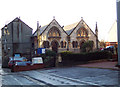
Bethel United Church of Jesus Christ Apostolic, Trowbridge
Image: © Maigheach-gheal
Taken: 16 Jan 2007
0.03 miles
2

All That Remains
The outside wall of what was the Ushers Brewery. Work starting to transform the site into luxury apartments.
Image: © Maigheach-gheal
Taken: 16 Jan 2007
0.07 miles
3
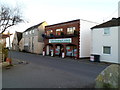
BCH Camping & Leisure, Trowbridge
Located at 8-12 Islington, Trowbridge, opposite Palmer Gardens. http://www.geograph.org.uk/photo/2760183
BCH is a family run business established in 1976, with stores also in Bath and Chippenham.
Image: © Jaggery
Taken: 5 Dec 2011
0.07 miles
4

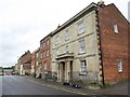
Grade II listed Waterloo Place, Trowbridge
Waterloo Place is a row of 5 late Georgian houses, 30-34 Union Street, built in the early 19th century. Grade II listed in December 1950.
Image: © Jaggery
Taken: 5 Dec 2011
0.08 miles
5
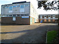
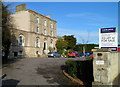
Former Trowbridge Family Health Centre
Some of the windows are boarded up and there is a For Sale sign on the property located on the corner of Union Street and The Halve.
Image: © Jaggery
Taken: 5 Dec 2011
0.08 miles
6
The Halve Strict Baptist Chapel, Trowbridge
Located at 30 The Halve. The congregation here are Strict Baptists who continue the doctrine of the early 17th century congregation at Southwick.
Image: © Jaggery
Taken: 5 Dec 2011
0.08 miles
7
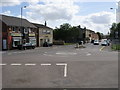
Timbrell Street
Timbrell Street from the roundabout with the B3106
Image: © Shaun Ferguson
Taken: 29 Aug 2009
0.08 miles
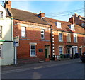
8
The Halve, Trowbridge
Listed buildings on the northeast side of the street. The nearest is the early C19 number 13, with distinctive double scroll shaping to the window recesses http://www.britishlistedbuildings.co.uk/en-314034-13-trowbridge . Next door is the older number 14 http://www.britishlistedbuildings.co.uk/en-314035-14-trowbridge .
Image: © Derek Harper
Taken: 20 Jul 2011
0.10 miles
9
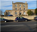
Grade II listed Bellefield House, Trowbridge
Built as a grand townhouse in the 1790s, now in use as offices. Located near the western end of Hilperton Road. Grade II listed in November 1976.
Image: © Jaggery
Taken: 5 Dec 2011
0.10 miles
10
Front view of Grade II listed Bellefield House, Trowbridge
Viewed across Hilperton Road. Built as a grand townhouse in the 1790s, now in use as offices.
Grade II listed in November 1976.
Image: © Jaggery
Taken: 5 Dec 2011
0.10 miles