IMAGES TAKEN NEAR TO
Conigre, TROWBRIDGE, BA14 8RE
Introduction
This page details the photographs taken nearby to Conigre, BA14 8RE by members of the Geograph project.
The Geograph project started in 2005 with the aim of publishing, organising and preserving representative images for every square kilometre of Great Britain, Ireland and the Isle of Man.

There are currently over 7.5m images from over14,400 individuals and you can help contribute to the project by visiting https://www.geograph.org.uk
Image Map
Images are licensed for reuse under creativecommons.org/licenses/by-sa/2.0
Notes
- Clicking on the map will re-center to the selected point.
- The higher the marker number, the further away the image location is from the centre of the postcode.
Image Listing (238 Images Found)
Images are licensed for reuse under creativecommons.org/licenses/by-sa/2.0
Image
Details
Distance
1
![Trowbridge houses [9]](https://s2.geograph.org.uk/geophotos/06/79/83/6798374_28217553_120x120.jpg)
Trowbridge houses [9]
On the left of the image is Conigre Parsonage, number 2 Conigre, is a large 'L'plan house built circa 1700 and given in 1731 to the use of the Minister of Conigre (Non-Conformist) Church. Constructed of brick, now stuccoed, with stone quoins, dressings and Doric style doorcase. Listed, grade II, with details at: https://historicengland.org.uk/listing/the-list/list-entry/1364214
On the right of the image is the former stable block to Westcroft Image, now converted into a dwelling and known as The Gate House. Listed, grade II, with details at: https://historicengland.org.uk/listing/the-list/list-entry/1364239
A market town and county town of Wiltshire, Trowbridge lies on the River Biss, 6 miles (10 kilometres) south of Bath. The town developed as a centre for woollen cloth production from the 14th century, which from the 17th century became increasingly industrialized, so much so that, in 1820, Trowbridge was described as the "Manchester of the West" with over 20 woollen cloth producing factories. The Kennet and Avon Canal runs just to the north of the town and both the Wessex Main Line (Bristol–Westbury–Southampton) and the Heart of Wessex Line (Bristol–Westbury–Weymouth) railways.
Image: © Michael Dibb
Taken: 14 Jan 2021
0.00 miles
2
![Trowbridge houses [11]](https://s2.geograph.org.uk/geophotos/06/79/97/6799714_06e337d3_120x120.jpg)
Trowbridge houses [11]
Beechwood House, Conigre, was built in brick with an ashlar double front in the late 18th century. The house was altered in the mid 19th century when the two square bay windows were inserted. There is a mansard roof. The property has been divided into flats. Listed, grade II, with details at: https://historicengland.org.uk/listing/the-list/list-entry/1021554
A market town and county town of Wiltshire, Trowbridge lies on the River Biss, 6 miles (10 kilometres) south of Bath. The town developed as a centre for woollen cloth production from the 14th century, which from the 17th century became increasingly industrialized, so much so that, in 1820, Trowbridge was described as the "Manchester of the West" with over 20 woollen cloth producing factories. The Kennet and Avon Canal runs just to the north of the town and both the Wessex Main Line (Bristol–Westbury–Southampton) and the Heart of Wessex Line (Bristol–Westbury–Weymouth) railways.
Image: © Michael Dibb
Taken: 14 Jan 2021
0.01 miles
3
![Trowbridge houses [8]](https://s3.geograph.org.uk/geophotos/06/79/83/6798371_a47d03c8_120x120.jpg)
Trowbridge houses [8]
Westcroft, in British Row is a 1784 reconstruction of an earlier house. The main front, seen here, is built of brick on a stone plinth. There are stone quoins, string course and cornice. There is a fine stone Doric doorcase. The single storey wing on the right is a later addition. There is a three-storey brick built wing forming the west front. Listed, grade II*, with details at: https://historicengland.org.uk/listing/the-list/list-entry/1182520
A market town and county town of Wiltshire, Trowbridge lies on the River Biss, 6 miles (10 kilometres) south of Bath. The town developed as a centre for woollen cloth production from the 14th century, which from the 17th century became increasingly industrialized, so much so that, in 1820, Trowbridge was described as the "Manchester of the West" with over 20 woollen cloth producing factories. The Kennet and Avon Canal runs just to the north of the town and both the Wessex Main Line (Bristol–Westbury–Southampton) and the Heart of Wessex Line (Bristol–Westbury–Weymouth) railways.
Image: © Michael Dibb
Taken: 14 Jan 2021
0.01 miles
4
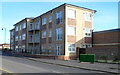
New flats, British Row, Trowbridge
Recently-built flats on the south side of British Row.
Image: © Jaggery
Taken: 5 Dec 2011
0.03 miles
5
![Trowbridge houses [7]](https://s1.geograph.org.uk/geophotos/06/79/83/6798369_96535f25_120x120.jpg)
Trowbridge houses [7]
Waldron's Square, numbers 1 and 2 British Row is a pair of 18th century houses. Built in brick with stone quoins and a mansard roof. Listed, grade II, with details at: https://historicengland.org.uk/listing/the-list/list-entry/1021526
A market town and county town of Wiltshire, Trowbridge lies on the River Biss, 6 miles (10 kilometres) south of Bath. The town developed as a centre for woollen cloth production from the 14th century, which from the 17th century became increasingly industrialized, so much so that, in 1820, Trowbridge was described as the "Manchester of the West" with over 20 woollen cloth producing factories. The Kennet and Avon Canal runs just to the north of the town and both the Wessex Main Line (Bristol–Westbury–Southampton) and the Heart of Wessex Line (Bristol–Westbury–Weymouth) railways.
Image: © Michael Dibb
Taken: 14 Jan 2021
0.03 miles
6
![Trowbridge houses [10]](https://s1.geograph.org.uk/geophotos/06/79/97/6799713_58076d4d_120x120.jpg)
Trowbridge houses [10]
Holly House, number 25 Conigre, is the surviving house of a terrace. Built in the early 19th century of brick with stone bands and quoins on the right. Listed, grade II, with details at: https://historicengland.org.uk/listing/the-list/list-entry/1021553
A market town and county town of Wiltshire, Trowbridge lies on the River Biss, 6 miles (10 kilometres) south of Bath. The town developed as a centre for woollen cloth production from the 14th century, which from the 17th century became increasingly industrialized, so much so that, in 1820, Trowbridge was described as the "Manchester of the West" with over 20 woollen cloth producing factories. The Kennet and Avon Canal runs just to the north of the town and both the Wessex Main Line (Bristol–Westbury–Southampton) and the Heart of Wessex Line (Bristol–Westbury–Weymouth) railways.
Image: © Michael Dibb
Taken: 14 Jan 2021
0.03 miles
7
![Trowbridge ways [2]](https://s3.geograph.org.uk/geophotos/06/79/70/6797075_ba6d0a06_120x120.jpg)
Trowbridge ways [2]
This path from Seymour Road, seen at Image, ends here where it meets British Row.
A market town and county town of Wiltshire, Trowbridge lies on the River Biss, 6 miles (10 kilometres) south of Bath. The town developed as a centre for woollen cloth production from the 14th century, which from the 17th century became increasingly industrialised, so much so that, in 1820, Trowbridge was described as the "Manchester of the West" with over 20 woollen cloth producing factories. The Kennet and Avon Canal runs just to the north of the town and both the Wessex Main Line (Bristol–Westbury–Southampton) and the Heart of Wessex Line (Bristol–Westbury–Weymouth) railways.
Image: © Michael Dibb
Taken: 14 Jan 2021
0.04 miles
8
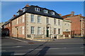
Grade II listed Conigre Parsonage, Trowbridge
Located on the corner of Conigre and Upper Broad Street.
Built c1700. In 1731 it was given to be used by the minister of Conigre Church.
Grade II listed in December 1950. The building is now divided into flats.
Image: © Jaggery
Taken: 5 Dec 2011
0.06 miles
9
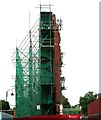
Remains of Usher's Brewery - Back Street
Image: © Betty Longbottom
Taken: 26 Aug 2008
0.07 miles
10
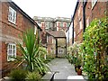
Weavers' Cottages - Hill Court, Riversway
Image: © Betty Longbottom
Taken: 26 Aug 2008
0.07 miles