Trowbridge houses [9]
Introduction
The photograph on this page of Trowbridge houses [9] by Michael Dibb as part of the Geograph project.
The Geograph project started in 2005 with the aim of publishing, organising and preserving representative images for every square kilometre of Great Britain, Ireland and the Isle of Man.

There are currently over 7.5m images from over 14,400 individuals and you can help contribute to the project by visiting https://www.geograph.org.uk
Trowbridge houses [9]
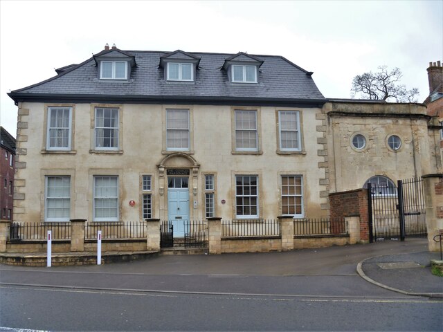
Image: © Michael Dibb Taken: 14 Jan 2021
On the left of the image is Conigre Parsonage, number 2 Conigre, is a large 'L'plan house built circa 1700 and given in 1731 to the use of the Minister of Conigre (Non-Conformist) Church. Constructed of brick, now stuccoed, with stone quoins, dressings and Doric style doorcase. Listed, grade II, with details at: https://historicengland.org.uk/listing/the-list/list-entry/1364214 On the right of the image is the former stable block to Westcroft Image, now converted into a dwelling and known as The Gate House. Listed, grade II, with details at: https://historicengland.org.uk/listing/the-list/list-entry/1364239 A market town and county town of Wiltshire, Trowbridge lies on the River Biss, 6 miles (10 kilometres) south of Bath. The town developed as a centre for woollen cloth production from the 14th century, which from the 17th century became increasingly industrialized, so much so that, in 1820, Trowbridge was described as the "Manchester of the West" with over 20 woollen cloth producing factories. The Kennet and Avon Canal runs just to the north of the town and both the Wessex Main Line (Bristol–Westbury–Southampton) and the Heart of Wessex Line (Bristol–Westbury–Weymouth) railways.
Images are licensed for reuse under creativecommons.org/licenses/by-sa/2.0
Image Location
Latitude
51.323072
Longitude
-2.211049