
IMAGES TAKEN NEAR TO
West Ashton Road, TROWBRIDGE, BA14 7BQ
Introduction
This page details the photographs taken nearby to West Ashton Road, BA14 7BQ by members of the Geograph project.
The Geograph project started in 2005 with the aim of publishing, organising and preserving representative images for every square kilometre of Great Britain, Ireland and the Isle of Man.

There are currently over 7.5m images from over14,400 individuals and you can help contribute to the project by visiting https://www.geograph.org.uk
Image Map
Images are licensed for reuse under creativecommons.org/licenses/by-sa/2.0
Notes
- Clicking on the map will re-center to the selected point.
- The higher the marker number, the further away the image location is from the centre of the postcode.
Image Listing (66 Images Found)
Images are licensed for reuse under creativecommons.org/licenses/by-sa/2.0
Image
Details
Distance
1
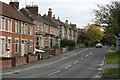
2007 : West Ashton Road
Trowbridge is a curate's egg of a town, this is one of the good bits. It is not all like this. For the other side of the coin see Image]
Image: © Maurice Pullin
Taken: 16 Oct 2007
0.02 miles
2
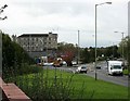
2007 : The Inner Ring Road (unfinished)
Trowbridge as a town was always functional rather than pretty, but it once had a certain charm. The uglification process began in the 1950's and is now well under way. This is the inner ring road, less than one third of it has been completed. Tesco's Super Store is off to the right and one of the old woollen mills is on the left.
Image: © Maurice Pullin
Taken: 16 Oct 2007
0.07 miles
3

Roundabout on County Way, Trowbridge
The rain wasn't friendly to photography and meant changing to the small camera to keep it off the lens. You can just see the Magnet store on the right.
Image: © David Howard
Taken: 21 Aug 2016
0.08 miles
4
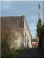
Ashton Mills, Trowbridge
The stone built single storey, north-light weaving sheds.
Image: © Chris Allen
Taken: 8 Jan 2012
0.09 miles
5
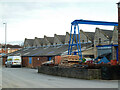
Ashton Mills, Trowbridge
Five storey stone mill with adjoining stone built weaving sheds and a brick engine house. Dates from 1860 and in the textile trade until 1963. This view shows the stone built north-light weaving shed. The multi-storey block is Grade II Listed.
Image: © Chris Allen
Taken: 8 Jan 2012
0.09 miles
6
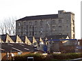
County Way heritage
The distinctive outline of the Ashton Mills buildings along County Way. Built in the mid-nineteenth century and now Grade II listed, they have a number of small offices and industrial businesses occupying the site.
Image: © Neil Owen
Taken: 26 Nov 2013
0.09 miles
7
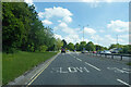
A361 County Way, Trowbridge
A partial ring road around the town centre.
Image: © Robin Webster
Taken: 30 May 2021
0.10 miles
8
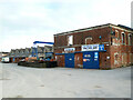
Ashton Mills, Trowbridge
Five storey stone mill with adjoining stone built weaving sheds and a brick engine house. Dates from 1860 and in the textile trade until 1963. This view shows the stone built north-light weaving shed and the brick built structure that I think was the engine house and boiler house complex. The chimney is long gone.
Image: © Chris Allen
Taken: 8 Jan 2012
0.10 miles
9
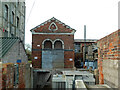
Ashton Mills, Trowbridge
Five storey stone mill with adjoining stone built weaving sheds and a brick engine house. Dates from 1860 and in the textile trade until 1963. This view shows the multi-storey block to the left and the sheds to the right with the apparent engine house in the middle. The booklet Power in the Trowbridge Woollen Industry by K H Rogers describes several sources of power for this mill complex and shows some confusing pictures (one referring to a vertical engine as a beam engine). The book refers to the first engine as being a twin beam engine by Hadens and of 60 horsepower. In 1908 these were replaced by an 80 horsepower Crossley gas engine and a 120 horsepower Tangye tandem compound steam engine. In 1933 the Tangye was replaced by a Davey, Paxman patent Peache two crank compound engine. This drove both a generator and lineshafting in the weaving shed.
Image: © Chris Allen
Taken: 8 Jan 2012
0.10 miles
10
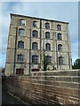
Ashton Mills, Trowbridge
Five storey stone mill with adjoining stone built weaving sheds and a brick engine house. Dates from 1860 and in the textile trade until 1963. This view shows the five storey block that is Grade II Listed.
Image: © Chris Allen
Taken: 8 Jan 2012
0.10 miles