IMAGES TAKEN NEAR TO
Gaston, TROWBRIDGE, BA14 6QA
Introduction
This page details the photographs taken nearby to Gaston, BA14 6QA by members of the Geograph project.
The Geograph project started in 2005 with the aim of publishing, organising and preserving representative images for every square kilometre of Great Britain, Ireland and the Isle of Man.

There are currently over 7.5m images from over14,400 individuals and you can help contribute to the project by visiting https://www.geograph.org.uk
Image Map
Images are licensed for reuse under creativecommons.org/licenses/by-sa/2.0
Notes
- Clicking on the map will re-center to the selected point.
- The higher the marker number, the further away the image location is from the centre of the postcode.
Image Listing (179 Images Found)
Images are licensed for reuse under creativecommons.org/licenses/by-sa/2.0
Image
Details
Distance
1
![Holt houses [26]](https://s3.geograph.org.uk/geophotos/06/41/52/6415283_052b38cc_120x120.jpg)
Holt houses [26]
Gaston Farmhouse is 16th century with a mid 17th century cross wing, altered in the 19th century. There are some original internal features. The roof timbers are original and somewhat unusual. Listed, grade II, with details at: https://historicengland.org.uk/listing/the-list/list-entry/1194369
Two miles north east of Bradford-on-Avon the village of Holt originally consisted of a settlement around the church and an area around a triangular green called The Ham. The village greatly expanded in the later 20th century. Primarily an agricultural village, it was briefly a spa and there was a woollen cloth mill and factories producing leather, gloves and beds. Now a commuter village with workers travelling to Melksham, Trowbridge and Bradford-on-Avon.
Image: © Michael Dibb
Taken: 7 Mar 2020
0.01 miles
2
![Holt ways [3]](https://s3.geograph.org.uk/geophotos/06/41/52/6415279_5c027d53_120x120.jpg)
Holt ways [3]
The public footpath runs from near the church across the fields to The Star.
Two miles north east of Bradford-on-Avon the village of Holt originally consisted of a settlement around the church and an area around a triangular green called The Ham. The village greatly expanded in the later 20th century. Primarily an agricultural village, it was briefly a spa and there was a woollen cloth mill and factories producing leather, gloves and beds. Now a commuter village with workers travelling to Melksham, Trowbridge and Bradford-on-Avon.
Image: © Michael Dibb
Taken: 7 Mar 2020
0.04 miles
3
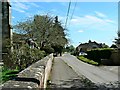
East along The Star, Holt, Wiltshire
St Katharine's Church is just visible at the left. The Star carries on for roughly a further kilometre before it joins the rather more prosaically named Station Road, which in turn leads to the site of Holt Junction station, closed in 1966.
Image: © Brian Robert Marshall
Taken: 6 May 2013
0.06 miles
4
![Holt houses [25]](https://s0.geograph.org.uk/geophotos/06/41/52/6415272_eb458fd4_120x120.jpg)
Holt houses [25]
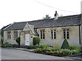
The Old School is a former National School, now a detached house. Built in 1834 and converted to residential use in the 1980s. Listed, grade II, with details at: https://historicengland.org.uk/listing/the-list/list-entry/1021798
Two miles north east of Bradford-on-Avon the village of Holt originally consisted of a settlement around the church and an area around a triangular green called The Ham. The village greatly expanded in the later 20th century. Primarily an agricultural village, it was briefly a spa and there was a woollen cloth mill and factories producing leather, gloves and beds. Now a commuter village with workers travelling to Melksham, Trowbridge and Bradford-on-Avon.
Image: © Michael Dibb
Taken: 7 Mar 2020
0.06 miles
6
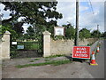
Old Holt cemetery on The Star
The road from Ham Green is The Star; along it is St Katharine's church and the old cemetery. A new burial ground was opened close by.
Image: © Neil Owen
Taken: 16 Aug 2021
0.06 miles
7
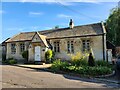
The old school, Gaston
Opposite St Katharine's church is the Old School, now a private residence.
Image: © Neil Owen
Taken: 16 Aug 2021
0.06 miles
8
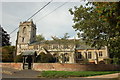
St Katherine's Church, Holt, Wiltshire
The parish church of St Katherine's in Holt
Image: © Gary Brothwell
Taken: 22 Sep 2010
0.08 miles
9
![Holt ways [4]](https://s1.geograph.org.uk/geophotos/06/41/59/6415933_0371cc7b_120x120.jpg)
Holt ways [4]
This track, alongside the church of St Katherine, provides access to some houses and then becomes a footpath leading to Station Road.
Two miles north east of Bradford-on-Avon the village of Holt originally consisted of a settlement around the church and an area around a triangular green called The Ham. The village greatly expanded in the later 20th century. Primarily an agricultural village, it was briefly a spa and there was a woollen cloth mill and factories producing leather, gloves and beds. Now a commuter village with workers travelling to Melksham, Trowbridge and Bradford-on-Avon.
Image: © Michael Dibb
Taken: 7 Mar 2020
0.08 miles
10
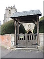
St Katharine's lychgate from Gaston
The wooden gate bears the motto 'God is Love'.
Image: © Neil Owen
Taken: 16 Aug 2021
0.08 miles