IMAGES TAKEN NEAR TO
The City, WESTBURY, BA13 4QQ
Introduction
This page details the photographs taken nearby to The City, BA13 4QQ by members of the Geograph project.
The Geograph project started in 2005 with the aim of publishing, organising and preserving representative images for every square kilometre of Great Britain, Ireland and the Isle of Man.

There are currently over 7.5m images from over14,400 individuals and you can help contribute to the project by visiting https://www.geograph.org.uk
Image Map
Images are licensed for reuse under creativecommons.org/licenses/by-sa/2.0
Notes
- Clicking on the map will re-center to the selected point.
- The higher the marker number, the further away the image location is from the centre of the postcode.
Image Listing (196 Images Found)
Images are licensed for reuse under creativecommons.org/licenses/by-sa/2.0
Image
Details
Distance
1
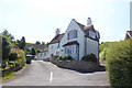
The City, Edington
An unusual name for a short cul-de-sac
Image: © David Smith
Taken: 1 Jun 2017
0.01 miles
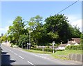
3
Road Junction in Edington
Stone and triangular junction, Edington.
Image: © Wayland Smith
Taken: 14 Sep 2020
0.12 miles
4
Road junction, Edington
A triangle of grass with a seat, litter bin and monumental stone
Image: © David Smith
Taken: 1 Jun 2017
0.14 miles
5
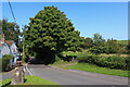
![Edington features [6]](https://s2.geograph.org.uk/geophotos/06/51/87/6518742_67c2d695_120x120.jpg)
Edington features [6]
The telephone pole looks much better with its coat of clemitis.
Edington is a former agricultural village which lies on the ‘springline’ of the northern escarpment of Salisbury Plain about 4 miles east of the town of Westbury. A priory was founded in the 14th century and became a monastery of the Brothers of Penitence, or Bonshommes. The magnificent monastery church continues in use as the parish church and is the home of the nationally-known annual Edington Music Festival.
Image: © Michael Dibb
Taken: 24 Apr 2020
0.19 miles
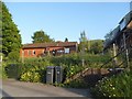
6

Field at Edington
A kissing gate leas to a public footpath across the field. The slopes of Edington Hill beyond.
Image: © Oliver Dixon
Taken: 8 Jun 2016
0.19 miles
7
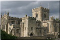
Edington Church
This former priory is like a little cathedral, or perhaps fortress, in the tiny village nestling against Salisbury Plain.
Image: © David Smart
Taken: 10 Aug 2005
0.19 miles
8
![Priory church [5]](https://s3.geograph.org.uk/geophotos/05/25/95/5259599_8a53cf0b_120x120.jpg)
Priory church [5]
This churchyard cross is possibly early 19th century. Restored in 1890. Listed, grade II, with details at: https://www.historicengland.org.uk/listing/the-list/list-entry/1364258
Edington is a former agricultural village which lies on the ‘springline’ of the northern escarpment of Salisbury Plain about 4 miles east of the town of Westbury. A priory was founded in the 14th century and became a monastery of the Brothers of Penitence, or Bonshommes. The magnificent monastery church continues in use as the parish church and is the home of the nationally-known annual Edington Music Festival.
Image: © Michael Dibb
Taken: 5 Jan 2017
0.20 miles
9
![Priory churchyard [1]](https://s1.geograph.org.uk/geophotos/05/24/82/5248277_a35212b8_120x120.jpg)
Priory churchyard [1]
The churchyard of the church of St Mary, St Katherine and All Saints has a large number of important monuments that are listed.
Edington is a former agricultural village which lies on the ‘springline’ of the northern escarpment of Salisbury Plain about 4 miles east of the town of Westbury. A priory was founded in the 14th century and became a monastery of the Brothers of Penitence, or Bonshommes. The magnificent monastery church continues in use as the parish church and is the home of the nationally-known annual Edington Music Festival.
Image: © Michael Dibb
Taken: 5 Jan 2017
0.20 miles
10
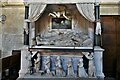
Edington Priory Church: The superb alabaster and marble Lewis Monument
Image: © Michael Garlick
Taken: 30 Sep 2021
0.20 miles