IMAGES TAKEN NEAR TO
Amazon Way, BA13 4GQ
Introduction
This page details the photographs taken nearby to Amazon Way, BA13 4GQ by members of the Geograph project.
The Geograph project started in 2005 with the aim of publishing, organising and preserving representative images for every square kilometre of Great Britain, Ireland and the Isle of Man.

There are currently over 7.5m images from over14,400 individuals and you can help contribute to the project by visiting https://www.geograph.org.uk
Image Map (Loading...)


Getting Data...Please wait
Leaflet Map data © OpenStreetMap
Images are licensed for reuse under creativecommons.org/licenses/by-sa/2.0
Notes
- Clicking on the map will re-center to the selected point.
- The higher the marker number, the further away the image location is from the centre of the postcode.
Image Listing (122 Images Found)
Images are licensed for reuse under creativecommons.org/licenses/by-sa/2.0
Image
Details
Distance
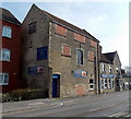
1
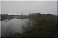
West Wilts Youth Sailing Association, Westbury
The building is at the Station Road edge of a small lake. West Wilts Youth Sailing Association is a charitable trust. Its primary aim is to introduce young people (ages 8-18) to the sport of sailing.
Image: © Jaggery
Taken: 8 Mar 2014
0.03 miles
2
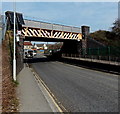
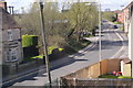
Station Road railway bridge, Westbury
The B3097 Station Road passes under a railway bridge, headroom 14 feet.
Image: © Jaggery
Taken: 8 Mar 2014
0.03 miles
3
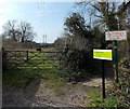
Private land at the edge of a Westbury lake
I was wondering whether I could circumambulate the edge of this http://www.geograph.org.uk/photo/4500750 lake. Then I saw these signs...
Image: © Jaggery
Taken: 8 Mar 2014
0.04 miles
5
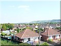
Westbury : Rooftops and Houses
Rooftops and houses in Westbury as seen from a passing train not heading into the nearby station.
Image: © Lewis Clarke
Taken: 1 Sep 2011
0.04 miles
6
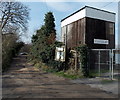
Bricked-up windows, The Railway Inn, Westbury
This building, with a door at first floor level, looks like former stables for horses dating from the time before the internal combustion engine. http://www.geograph.org.uk/photo/3879410 to the main part of The Railway Inn.
Image: © Jaggery
Taken: 8 Mar 2014
0.04 miles
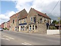
8
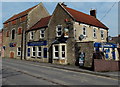
The Railway Inn, Westbury
Viewed across the B3097 Station Road. The Railway Inn is about 400 metres from the entrance to Westbury railway station. http://www.geograph.org.uk/photo/3879399 The subtext on the nameboard is
"The Station's Alternative Waiting Room".
Image: © Jaggery
Taken: 8 Mar 2014
0.05 miles
9
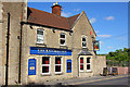
Railway Inn, Westbury
Pub near Westbury Railway Station.
Image: © Wayland Smith
Taken: 12 May 2011
0.06 miles