IMAGES TAKEN NEAR TO
Duck Lane, WESTBURY, BA13 4FW
Introduction
This page details the photographs taken nearby to Duck Lane, BA13 4FW by members of the Geograph project.
The Geograph project started in 2005 with the aim of publishing, organising and preserving representative images for every square kilometre of Great Britain, Ireland and the Isle of Man.

There are currently over 7.5m images from over14,400 individuals and you can help contribute to the project by visiting https://www.geograph.org.uk
Image Map (Loading...)


Getting Data...Please wait
Leaflet Map data © OpenStreetMap
Images are licensed for reuse under creativecommons.org/licenses/by-sa/2.0
Notes
- Clicking on the map will re-center to the selected point.
- The higher the marker number, the further away the image location is from the centre of the postcode.
Image Listing (127 Images Found)
Images are licensed for reuse under creativecommons.org/licenses/by-sa/2.0
Image
Details
Distance
1
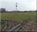
Muddy field near Oldfield Road, Westbury
Viewed from a track, a SW continuation of Station Approach.
Image: © Jaggery
Taken: 8 Mar 2014
0.05 miles
2
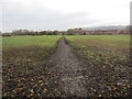
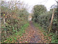
Path to Oldfield Road
Public footpath West15 crossing field. The Westbury White Horse can be viewed in the distance, located on the edge of Bratton Downs on the escarpment of Salisbury Plain.
Image: © Peter Holmes
Taken: 7 Dec 2013
0.06 miles
3
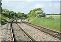
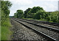
2008 : Westbury rail bypass
On the main line between Paddington and Exeter, the bypass avoids Westbury Station. You don't stand here for very long.
No railway was trespassed on during the taking of this photo. It was taken from a level crossing.
Image: © Maurice Pullin
Taken: 19 May 2008
0.07 miles
5
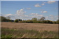
Route to Westbury Station
Track linking footpath West15 with Westbury Station.
Image: © Peter Holmes
Taken: 7 Dec 2013
0.08 miles
6

2008 : Modern housing, Westbury
On an estate so new it doesn't seem to have a name yet. Not a bad spot though a bit near the railway. In walking distance of the town centre if you are so minded.
Image: © Maurice Pullin
Taken: 19 May 2008
0.11 miles
7
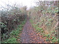
Path to Penleigh Farm
Public footpath West15.
Image: © Peter Holmes
Taken: 7 Dec 2013
0.11 miles
8
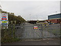
DB Schenker sidings
At Station Approach, Westbury.
Image: © Peter Holmes
Taken: 7 Dec 2013
0.12 miles
9
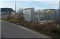
Electricity substation at the edge of railway sidings in Westbury
To the south of Westbury railway station.
Image: © Jaggery
Taken: 8 Mar 2014
0.12 miles
10
2008 : The Westbury bypass line (2)
Not a place to linger. The line is mostly used by high speed trains avoiding Westbury Station. It can also be used by freight trains carrying stone from the Mendips.
This was taken from a public footpath crossing the track.
Image: © Maurice Pullin
Taken: 19 May 2008
0.12 miles