IMAGES TAKEN NEAR TO
Dilton Marsh, WESTBURY, BA13 4DF
Introduction
This page details the photographs taken nearby to BA13 4DF by members of the Geograph project.
The Geograph project started in 2005 with the aim of publishing, organising and preserving representative images for every square kilometre of Great Britain, Ireland and the Isle of Man.

There are currently over 7.5m images from over14,400 individuals and you can help contribute to the project by visiting https://www.geograph.org.uk
Image Map
Images are licensed for reuse under creativecommons.org/licenses/by-sa/2.0
Notes
- Clicking on the map will re-center to the selected point.
- The higher the marker number, the further away the image location is from the centre of the postcode.
Image Listing (4 Images Found)
Images are licensed for reuse under creativecommons.org/licenses/by-sa/2.0
Image
Details
Distance
1
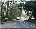
2010 : A3098 at the end of Short Street
Heading east to Westbury where it meets the A350 and comes to an end.
Image: © Maurice Pullin
Taken: 31 Jan 2010
0.16 miles
2
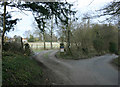
2010 : Short Street at the entrance to Short Street Farm
The sign warns of children playing.
Image: © Maurice Pullin
Taken: 31 Jan 2010
0.18 miles
3
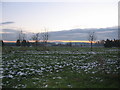
Thoulstone Park Golf Course
Looking south over Thoulstone Park golf course. The snow covered slopes of Cley Hill, near Warminster, can be seen in the distance at centre.
Image: © Phil Williams
Taken: 29 Nov 2005
0.23 miles
4
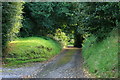
2008 : Approach to Short Street
Turning our backs on Image] we find this quiet lane.
Image: © Maurice Pullin
Taken: 1 Sep 2008
0.24 miles