IMAGES TAKEN NEAR TO
Gloucester Walk, WESTBURY, BA13 3XG
Introduction
This page details the photographs taken nearby to Gloucester Walk, BA13 3XG by members of the Geograph project.
The Geograph project started in 2005 with the aim of publishing, organising and preserving representative images for every square kilometre of Great Britain, Ireland and the Isle of Man.

There are currently over 7.5m images from over14,400 individuals and you can help contribute to the project by visiting https://www.geograph.org.uk
Image Map (Loading...)


Getting Data...Please wait
Leaflet Map data © OpenStreetMap
Images are licensed for reuse under creativecommons.org/licenses/by-sa/2.0
Notes
- Clicking on the map will re-center to the selected point.
- The higher the marker number, the further away the image location is from the centre of the postcode.
Image Listing (50 Images Found)
Images are licensed for reuse under creativecommons.org/licenses/by-sa/2.0
Image
Details
Distance
1

Gloucester Walk entrance, Westbury
The entrance to Gloucester Walk, Westbury, Wiltshire on an autumnal night with the main road leading to The Mead running round behind and to the right of the photographer.
Image: © Philip Reed
Taken: 14 Nov 2008
0.03 miles
2
Westbury Hill
A view looking east to Westbury Hill. The Westbury White Horse stands out as a dark shape against the recent light snowfall. Traffic can be seen on the A350 Trowbridge Road in the middle distance.
Image: © Phil Williams
Taken: 28 Feb 2006
0.03 miles
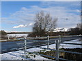
3
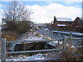
The Mead
A view looking southeast along The Mead from the footpath leading to the new catchment pond, adjacent to the culvert carrying Bitham Brook under the road.
Image: © Phil Williams
Taken: 28 Feb 2006
0.03 miles
4
Ducks on Bitham Brook
A view looking north along Bitham Brook towards the culvert taking the stream under The Mead.
Image: © Phil Williams
Taken: 28 Feb 2006
0.03 miles
5
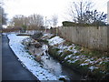
Bitham Brook
A view to the southeast along Bitham Brook from the footpath between Frogmore Road and The Mead.
Image: © Phil Williams
Taken: 28 Feb 2006
0.04 miles
6
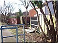
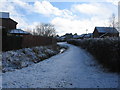
Storm-damaged fences at Gloucester Walk
Looking south along the back of houses at Gloucester Walk, off The Mead, Westbury
Image: © Philip Reed
Taken: 25 Jan 2007
0.05 miles
7
The Mead
A view looking northeast across The Meadfrom the footpath from frogmore Road, The Lafarge cement works chimney can be seen at left, with the shape of the Westbury White Horse appearing dark against the recent snowfall to the right of the tree.
Image: © Phil Williams
Taken: 28 Feb 2006
0.08 miles
8
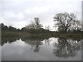
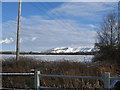
Catchment Pond at The Mead
The frozen surface of this catchment pond reflects the dull November skies. The pond was created as part of a nearby housing development. The Westbury Avoiding Line, part of the Paddington to Penzance rail line, can be seen amongst the bushes in the background.
Image: © Phil Williams
Taken: 27 Nov 2005
0.09 miles
9
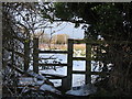
Disused stile
A view looking northwest to a catchment pond off The Mead. This stile has been made redundant since the pond has been landscaped as a recreation area.
Image: © Phil Williams
Taken: 28 Feb 2006
0.09 miles
10
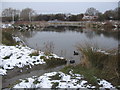
Coots on the Mead pond
A view looking northwest over the Mead pond, following a recent light snowfall.
Image: © Phil Williams
Taken: 28 Feb 2006
0.09 miles