IMAGES TAKEN NEAR TO
Brabant Way, WESTBURY, BA13 3UW
Introduction
This page details the photographs taken nearby to Brabant Way, BA13 3UW by members of the Geograph project.
The Geograph project started in 2005 with the aim of publishing, organising and preserving representative images for every square kilometre of Great Britain, Ireland and the Isle of Man.

There are currently over 7.5m images from over14,400 individuals and you can help contribute to the project by visiting https://www.geograph.org.uk
Image Map (Loading...)


Getting Data...Please wait
Leaflet Map data © OpenStreetMap
Images are licensed for reuse under creativecommons.org/licenses/by-sa/2.0
Notes
- Clicking on the map will re-center to the selected point.
- The higher the marker number, the further away the image location is from the centre of the postcode.
Image Listing (59 Images Found)
Images are licensed for reuse under creativecommons.org/licenses/by-sa/2.0
Image
Details
Distance
1
![Westbury buildings [6]](https://s3.geograph.org.uk/geophotos/06/80/58/6805811_fddf3eee_120x120.jpg)
Westbury buildings [6]
Pretentiously named Phipps Manor, this is the former Phipps Arms public house at 102 Westbury Leigh. Previously named The Black Horse, it closed in 2002. Built in brick in the early 19th century with a lean to addition on the right. The hideous porch is a recent addition. Listed, grade II, with details at: https://historicengland.org.uk/listing/the-list/list-entry/1036322
Westbury is a former market town in the far west of Wiltshire under the north western edge of Salisbury Plain, 4 miles south of Trowbridge and 4 miles north of Warminster. Westbury was a centre of the cloth industry from the later 15th century until the 19th century. Malting was another important industry. There are now a number of large industrial and trading estates around the town with many residents working there. The town is an important junction point on the railway network with the Reading to Taunton line intersecting the line from Bristol to Southampton.
Westbury Leigh is sometimes considered a separate village, with its own church and chapel, although it is now a contiguous part of the town.
Image: © Michael Dibb
Taken: 9 Feb 2021
0.07 miles
2
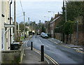
2010 : Westbury Leigh looking east
About 150 yards further on from Image] passing through the traffic lights. Black Horse Lane is to the left.
Image: © Maurice Pullin
Taken: 31 Jan 2010
0.08 miles
3
![Westbury ways [6]](https://s3.geograph.org.uk/geophotos/06/80/81/6808127_76a9e016_120x120.jpg)
Westbury ways [6]
Blackhorse Lane continues on the other side of Suffolk Road. The lane starts from Westbury Leigh, crosses Suffolk Road and runs to Dartmoor Road where it meets a complex of public footpaths.
Westbury is a former market town in the far west of Wiltshire under the north western edge of Salisbury Plain, 4 miles south of Trowbridge and 4 miles north of Warminster. Westbury was a centre of the cloth industry from the later 15th century until the 19th century. Malting was another important industry. There are now a number of large industrial and trading estates around the town with many residents working there. The town is an important junction point on the railway network with the Reading to Taunton line intersecting the line from Bristol to Southampton.
Westbury Leigh is sometimes considered a separate village, with its own church and chapel, although it is now a contiguous part of the town.
Image: © Michael Dibb
Taken: 9 Feb 2021
0.08 miles
4
![Westbury ways [7]](https://s1.geograph.org.uk/geophotos/06/80/81/6808129_2f9784e6_120x120.jpg)
Westbury ways [7]
Blackhorse Lane looking back towards Westbury Leigh from Suffolk Road. The lane starts from Westbury Leigh, crosses Suffolk Road and runs to Dartmoor Road where it meets a complex of public footpaths.
Westbury is a former market town in the far west of Wiltshire under the north western edge of Salisbury Plain, 4 miles south of Trowbridge and 4 miles north of Warminster. Westbury was a centre of the cloth industry from the later 15th century until the 19th century. Malting was another important industry. There are now a number of large industrial and trading estates around the town with many residents working there. The town is an important junction point on the railway network with the Reading to Taunton line intersecting the line from Bristol to Southampton.
Westbury Leigh is sometimes considered a separate village, with its own church and chapel, although it is now a contiguous part of the town.
Image: © Michael Dibb
Taken: 9 Feb 2021
0.08 miles
5
![Westbury ways [5]](https://s2.geograph.org.uk/geophotos/06/80/81/6808126_e1b7a6af_120x120.jpg)
Westbury ways [5]
Blackhorse Lane approaches Suffolk Road. The lane starts from Westbury Leigh, crosses Suffolk Road and runs to Dartmoor Road where it meets a complex of public footpaths.
Westbury is a former market town in the far west of Wiltshire under the north western edge of Salisbury Plain, 4 miles south of Trowbridge and 4 miles north of Warminster. Westbury was a centre of the cloth industry from the later 15th century until the 19th century. Malting was another important industry. There are now a number of large industrial and trading estates around the town with many residents working there. The town is an important junction point on the railway network with the Reading to Taunton line intersecting the line from Bristol to Southampton.
Westbury Leigh is sometimes considered a separate village, with its own church and chapel, although it is now a contiguous part of the town.
Image: © Michael Dibb
Taken: 9 Feb 2021
0.09 miles
6
![Westbury houses [13]](https://s3.geograph.org.uk/geophotos/06/80/58/6805807_8639ab60_120x120.jpg)
Westbury houses [13]
Applegarth, number 97 Westbury Leigh, was built in the late 18th or early 19th century, in brick with stone dressings. The house is set back from the street with a fine 19th century retaining wall. Listed, grade II, with details at: https://historicengland.org.uk/listing/the-list/list-entry/1364368
Westbury is a former market town in the far west of Wiltshire under the north western edge of Salisbury Plain, 4 miles south of Trowbridge and 4 miles north of Warminster. Westbury was a centre of the cloth industry from the later 15th century until the 19th century. Malting was another important industry. There are now a number of large industrial and trading estates around the town with many residents working there. The town is an important junction point on the railway network with the Reading to Taunton line intersecting the line from Bristol to Southampton.
Westbury Leigh is sometimes considered a separate village, with its own church and chapel, although it is now a contiguous part of the town.
Image: © Michael Dibb
Taken: 9 Feb 2021
0.10 miles
7
![Westbury features [2]](https://s3.geograph.org.uk/geophotos/06/80/81/6808151_ca20daa3_120x120.jpg)
Westbury features [2]
Along Blackhorse Lane is this length of wall which was the garden wall to Boyer's House Image The wall has been restored, lowered, and capped with brick. The garden has been developed for housing. The wall is listed, grade II, with details at: https://historicengland.org.uk/listing/the-list/list-entry/1180341
Blackhorse Lane starts from Westbury Leigh, crosses Suffolk Road and runs to Dartmoor Road where it meets a complex of public footpaths.
Westbury is a former market town in the far west of Wiltshire under the north western edge of Salisbury Plain, 4 miles south of Trowbridge and 4 miles north of Warminster. Westbury was a centre of the cloth industry from the later 15th century until the 19th century. Malting was another important industry. There are now a number of large industrial and trading estates around the town with many residents working there. The town is an important junction point on the railway network with the Reading to Taunton line intersecting the line from Bristol to Southampton.
Westbury Leigh is sometimes considered a separate village, with its own church and chapel, although it is now a contiguous part of the town.
Image: © Michael Dibb
Taken: 9 Feb 2021
0.10 miles
8
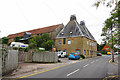
The Malthouse, Westbury Leigh
Grade II listed http://list.english-heritage.org.uk/resultsingle.aspx?uid=1181503
Image: © Oast House Archive
Taken: 25 Aug 2013
0.10 miles
9
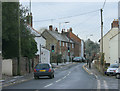
2010 : The Narrows, Westbury Leigh
"The Narrows" that is what I call this stretch of road, don't like to think what the locals call it.
The main road out of Westbury Leigh to the west and the cause of many holdups until the bypass was opened.
Image: © Maurice Pullin
Taken: 31 Jan 2010
0.10 miles
10
![Westbury buildings [5]](https://s2.geograph.org.uk/geophotos/06/80/58/6805806_1dfe6983_120x120.jpg)
Westbury buildings [5]
The Malthouse, Westbury Leigh was built in the early 19th century, probably on the site of a much earlier malthouse. Constructed of rubble stone with a pair of oast houses adjacent to the street. At the present time (April, 2021) the building is for sale. There is another view of the building at Image Listed, grade II, with details at: https://historicengland.org.uk/listing/the-list/list-entry/1181503
Westbury is a former market town in the far west of Wiltshire under the north western edge of Salisbury Plain, 4 miles south of Trowbridge and 4 miles north of Warminster. Westbury was a centre of the cloth industry from the later 15th century until the 19th century. Malting was another important industry. There are now a number of large industrial and trading estates around the town with many residents working there. The town is an important junction point on the railway network with the Reading to Taunton line intersecting the line from Bristol to Southampton.
Westbury Leigh is sometimes considered a separate village, with its own church and chapel, although it is now a contiguous part of the town.
Image: © Michael Dibb
Taken: 9 Feb 2021
0.10 miles