IMAGES TAKEN NEAR TO
WESTBURY, BA13 3SR
Introduction
This page details the photographs taken nearby to BA13 3SR by members of the Geograph project.
The Geograph project started in 2005 with the aim of publishing, organising and preserving representative images for every square kilometre of Great Britain, Ireland and the Isle of Man.

There are currently over 7.5m images from over14,400 individuals and you can help contribute to the project by visiting https://www.geograph.org.uk
Image Map
Images are licensed for reuse under creativecommons.org/licenses/by-sa/2.0
Notes
- Clicking on the map will re-center to the selected point.
- The higher the marker number, the further away the image location is from the centre of the postcode.
Image Listing (50 Images Found)
Images are licensed for reuse under creativecommons.org/licenses/by-sa/2.0
Image
Details
Distance
1
![Westbury ways [4]](https://s3.geograph.org.uk/geophotos/06/80/81/6808123_a3e73776_120x120.jpg)
Westbury ways [4]
Seen from Westbury Leigh, Mill Lane is a short no-through-road which then becomes a public footpath to Old Dilton.
Westbury is a former market town in the far west of Wiltshire under the north western edge of Salisbury Plain, 4 miles south of Trowbridge and 4 miles north of Warminster. Westbury was a centre of the cloth industry from the later 15th century until the 19th century. Malting was another important industry. There are now a number of large industrial and trading estates around the town with many residents working there. The town is an important junction point on the railway network with the Reading to Taunton line intersecting the line from Bristol to Southampton.
Westbury Leigh is sometimes considered a separate village, with its own church and chapel, although it is now a contiguous part of the town.
Image: © Michael Dibb
Taken: 9 Feb 2021
0.04 miles
2
![Westbury buildings [9]](https://s2.geograph.org.uk/geophotos/06/80/81/6808118_5bd38f1f_120x120.jpg)
Westbury buildings [9]
The warnings of unsafe buildings at Bridge Farmyard suggest that the farm is no longer a working farm.
Westbury is a former market town in the far west of Wiltshire under the north western edge of Salisbury Plain, 4 miles south of Trowbridge and 4 miles north of Warminster. Westbury was a centre of the cloth industry from the later 15th century until the 19th century. Malting was another important industry. There are now a number of large industrial and trading estates around the town with many residents working there. The town is an important junction point on the railway network with the Reading to Taunton line intersecting the line from Bristol to Southampton.
Westbury Leigh is sometimes considered a separate village, with its own church and chapel, although it is now a contiguous part of the town.
Image: © Michael Dibb
Taken: 9 Feb 2021
0.06 miles
3
![Westbury buildings [8]](https://s2.geograph.org.uk/geophotos/06/80/66/6806606_6882fca2_120x120.jpg)
Westbury buildings [8]
Now known as Bridge Farmhouse, Westbury Leigh, this was formerly the Apple Tree Inn which closed in 1955. The rear range was originally timber framed from the early/mid 17th century and was rebuilt in brick. The range along the street is 18th century in ashlar. There are some 19th century additions. Listed, grade II, with details at: https://historicengland.org.uk/listing/the-list/list-entry/1021479
Westbury is a former market town in the far west of Wiltshire under the north western edge of Salisbury Plain, 4 miles south of Trowbridge and 4 miles north of Warminster. Westbury was a centre of the cloth industry from the later 15th century until the 19th century. Malting was another important industry. There are now a number of large industrial and trading estates around the town with many residents working there. The town is an important junction point on the railway network with the Reading to Taunton line intersecting the line from Bristol to Southampton.
Westbury Leigh is sometimes considered a separate village, with its own church and chapel, although it is now a contiguous part of the town.
Image: © Michael Dibb
Taken: 9 Feb 2021
0.06 miles
4
![Westbury features [1]](https://s0.geograph.org.uk/geophotos/06/80/81/6808120_519f10e1_120x120.jpg)
Westbury features [1]
Biss Brook, the headwaters of the River Biss, seen from the bridge that carries Westbury Leigh.
Westbury is a former market town in the far west of Wiltshire under the north western edge of Salisbury Plain, 4 miles south of Trowbridge and 4 miles north of Warminster. Westbury was a centre of the cloth industry from the later 15th century until the 19th century. Malting was another important industry. There are now a number of large industrial and trading estates around the town with many residents working there. The town is an important junction point on the railway network with the Reading to Taunton line intersecting the line from Bristol to Southampton.
Westbury Leigh is sometimes considered a separate village, with its own church and chapel, although it is now a contiguous part of the town.
Image: © Michael Dibb
Taken: 9 Feb 2021
0.06 miles
5
![Westbury houses [18]](https://s3.geograph.org.uk/geophotos/06/80/66/6806603_86c62ae1_120x120.jpg)
Westbury houses [18]
Number 145 Westbury Leigh is dated 1591. A timber framed building with brick noggin which is pebbledashed except for the projecting gabled extension. Internally there is panelling and several original fireplaces, one with a Tudor arch and bread oven. Listed, grade II, with details at: https://historicengland.org.uk/listing/the-list/list-entry/1181545
Westbury is a former market town in the far west of Wiltshire under the north western edge of Salisbury Plain, 4 miles south of Trowbridge and 4 miles north of Warminster. Westbury was a centre of the cloth industry from the later 15th century until the 19th century. Malting was another important industry. There are now a number of large industrial and trading estates around the town with many residents working there. The town is an important junction point on the railway network with the Reading to Taunton line intersecting the line from Bristol to Southampton.
Westbury Leigh is sometimes considered a separate village, with its own church and chapel, although it is now a contiguous part of the town.
Image: © Michael Dibb
Taken: 9 Feb 2021
0.07 miles
6
2010 : West out of Westbury Leigh
Through Penknap toward the A3098, by a roundabout route due to the new bypass.
Image: © Maurice Pullin
Taken: 31 Jan 2010
0.08 miles
7
![Westbury ways [3]](https://s1.geograph.org.uk/geophotos/06/80/81/6808121_5a595306_120x120.jpg)
Westbury ways [3]
Seen from Westbury Leigh, the path runs alongside Biss Brook to Leigh Park.
Westbury is a former market town in the far west of Wiltshire under the north western edge of Salisbury Plain, 4 miles south of Trowbridge and 4 miles north of Warminster. Westbury was a centre of the cloth industry from the later 15th century until the 19th century. Malting was another important industry. There are now a number of large industrial and trading estates around the town with many residents working there. The town is an important junction point on the railway network with the Reading to Taunton line intersecting the line from Bristol to Southampton.
Westbury Leigh is sometimes considered a separate village, with its own church and chapel, although it is now a contiguous part of the town.
Image: © Michael Dibb
Taken: 9 Feb 2021
0.08 miles
8
![Westbury houses [17]](https://s1.geograph.org.uk/geophotos/06/80/66/6806601_933351cc_120x120.jpg)
Westbury houses [17]
Number 143 Westbury Leigh is a 17th century cottage, later extended on both sides and attached to number 145. The house is timber framed with pebbledash and the front is angled to the street. The interior has been much altered and modernized. Listed, grade II, with details at: https://historicengland.org.uk/listing/the-list/list-entry/1364369
Westbury is a former market town in the far west of Wiltshire under the north western edge of Salisbury Plain, 4 miles south of Trowbridge and 4 miles north of Warminster. Westbury was a centre of the cloth industry from the later 15th century until the 19th century. Malting was another important industry. There are now a number of large industrial and trading estates around the town with many residents working there. The town is an important junction point on the railway network with the Reading to Taunton line intersecting the line from Bristol to Southampton.
Westbury Leigh is sometimes considered a separate village, with its own church and chapel, although it is now a contiguous part of the town.
Image: © Michael Dibb
Taken: 9 Feb 2021
0.08 miles
9
![Westbury buildings [7]](https://s0.geograph.org.uk/geophotos/06/80/66/6806600_dd68ddaa_120x120.jpg)
Westbury buildings [7]
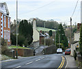
This impressive chapel was built in 1797 and was altered and enlarged several times between 1847 and 1871. Constructed in brick with ashlar dressings. After becoming redundant, the building was sold and was to be converted into 4 apartments. The developer failed to request listed building content and demolished the listed gate piers and the development stalled. The building is currently being advertised as a 3-bedroom house which will be ready for occupation in early 2022. Listed, grade II, with details at: https://historicengland.org.uk/listing/the-list/list-entry/1284948
Westbury is a former market town in the far west of Wiltshire under the north western edge of Salisbury Plain, 4 miles south of Trowbridge and 4 miles north of Warminster. Westbury was a centre of the cloth industry from the later 15th century until the 19th century. Malting was another important industry. There are now a number of large industrial and trading estates around the town with many residents working there. The town is an important junction point on the railway network with the Reading to Taunton line intersecting the line from Bristol to Southampton.
Westbury Leigh is sometimes considered a separate village, with its own church and chapel, although it is now a contiguous part of the town.
Image: © Michael Dibb
Taken: 9 Feb 2021
0.09 miles
10

2010 : Traffic lights at Westbury Leigh
Controlling traffic through a narrow section on a fairly busy road.
This is the former A3098 before it was bypassed.
Image: © Maurice Pullin
Taken: 31 Jan 2010
0.09 miles