Westbury buildings [7]
Introduction
The photograph on this page of Westbury buildings [7] by Michael Dibb as part of the Geograph project.
The Geograph project started in 2005 with the aim of publishing, organising and preserving representative images for every square kilometre of Great Britain, Ireland and the Isle of Man.

There are currently over 7.5m images from over 14,400 individuals and you can help contribute to the project by visiting https://www.geograph.org.uk
Westbury buildings [7]
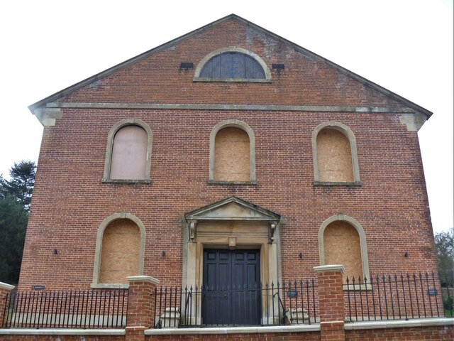
Image: © Michael Dibb Taken: 9 Feb 2021
This impressive chapel was built in 1797 and was altered and enlarged several times between 1847 and 1871. Constructed in brick with ashlar dressings. After becoming redundant, the building was sold and was to be converted into 4 apartments. The developer failed to request listed building content and demolished the listed gate piers and the development stalled. The building is currently being advertised as a 3-bedroom house which will be ready for occupation in early 2022. Listed, grade II, with details at: https://historicengland.org.uk/listing/the-list/list-entry/1284948 Westbury is a former market town in the far west of Wiltshire under the north western edge of Salisbury Plain, 4 miles south of Trowbridge and 4 miles north of Warminster. Westbury was a centre of the cloth industry from the later 15th century until the 19th century. Malting was another important industry. There are now a number of large industrial and trading estates around the town with many residents working there. The town is an important junction point on the railway network with the Reading to Taunton line intersecting the line from Bristol to Southampton. Westbury Leigh is sometimes considered a separate village, with its own church and chapel, although it is now a contiguous part of the town.
Images are licensed for reuse under creativecommons.org/licenses/by-sa/2.0
Image Location
Latitude
51.247467
Longitude
-2.202249